
Chalmette
| Chalmette | |||
|---|---|---|---|
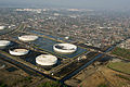
 Aerial view of Chalmette |
|||
| Location in Louisiana | |||
|
|||
| Basic data | |||
| State : | United States | ||
| State : | Louisiana | ||
| Parish : | St. Bernard Parish | ||
| Coordinates : | 29 ° 57 ′ N , 89 ° 58 ′ W | ||
| Time zone : | Central ( UTC − 6 / −5 ) | ||
| Residents : | 16,751 (as of 2010) | ||
| Population density : | 817.1 inhabitants per km 2 | ||
| Area : | 20.5 km 2 (approx. 8 mi 2 ) | ||
| Height : | 1 m | ||
| Postcodes : | 70043, 70044 | ||
| Area code : | +1 504 | ||
| FIPS : | 22-14135 | ||
| GNIS ID : | 1629922 | ||
 The St. Bernard Parish Courthouse in Chalmette |
|||

Chalmette is a town and administrative center ( Parish Seat ) of the St. Bernard Parish in US -amerikanischen State Louisiana and part of New Orleans - Metairie - Kenner Metropolitan Statistical Area .
geography
Chalmette is located at latitude 29 ° 56'44 "north and longitude 89 ° 57'42" west and lies between the Mississippi River in the south and the Mississippi River - Gulf Outlet Canal in the north. New Orleans joins directly to the northwest. The Interstate 10 highway runs northwest nearby.
history
The town was named after Martin de Lino de Chalmette, who was of French descent and who ran plantations in the area.
Battle of New Orleans
Became famous the place, since in 1815 the Battle of New Orleans ( Battle of New Orleans took place). The British troops were then subject to the US forces under Andrew Jackson , who later became President of the United States . The battlefield and the adjacent cemetery are national monuments of the United States. 15,300 veterans of various wars were buried in the cemetery.

Battlefield
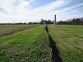
Battlefield with a memorial

Cemetery next to the battlefield
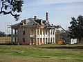
Plantation House in repair work after Hurricane Katrina


Hurricane Katrina
On August 29, 2005, Hurricane Katrina hit and flooded the city. The water entered in particular from the Mississippi River - Gulf Outlet Canal. As a result, the city was almost completely destroyed. Just before the hurricane hit the city, many people were evacuated. Still, there were large numbers of fatalities. In addition to the considerable destruction, there was also environmental damage caused by oil leaking from damaged oil tanks. Many houses were later declared “not to be saved” or “not fit for renovation”, and the residents were housed in trailer parks . A year after the disaster, the clean-up work was ongoing. Parts of the historic battlefield and the cemetery were also flooded. The damaged visitor center was repaired and reopened in 2007.
It wasn't until 2008 that many companies returned to Chalmette. However, the population was well below the pre-hurricane numbers. Meanwhile the popular Mardi Gras carnival is celebrated again.

Hurricane Katrina in the Gulf of Mexico

Aerial view
Oil leaks
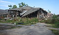
Destroyed house
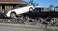
Demolished vehicles
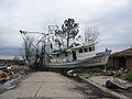
Boat washed ashore


Demographic data
In 2007 a population of 16,008 people was determined, which means a halving compared to the year 2000. The median age in 2007 was 37.3 years.
Individual evidence
Web links
- Chalmette history
- Chalmette Battlefield - Visitor Information Battlefield
- Chalmette photos after Hurricane Katrina Hurricane Katrina
- city-data population figures