Chandler River (Macleay River)
| Chandler River | ||
|
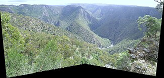
Halls Peak Mine and Chandler River in Oxley Wild Rivers National Park |
||
| Data | ||
| location | New South Wales , Australia | |
| River system | Macleay River | |
| Drain over | Macleay River → Tasman Sea | |
| source | at Rockvale (west of Cathedral Rock National Park ) 30 ° 20 ′ 47 ″ S , 152 ° 1 ′ 8 ″ E |
|
| Source height | 1260 m | |
| muzzle |
Macleay River in Oxley Wild Rivers National Park Coordinates: 30 ° 47 ′ 57 ″ E , 152 ° 0 ′ 48 ″ E 30 ° 47 ′ 57 ″ S , 152 ° 0 ′ 48 ″ E |
|
| Mouth height | 209 m | |
| Height difference | 1051 m | |
| Bottom slope | 9.5 ‰ | |
| length | 111 km | |
| Left tributaries | Chandelina Creek, Maiden Creek, Station Creek, Oaky River , Styx River | |
| Right tributaries | Wollomombi River | |
| Small towns | Wollomombi | |
|
Chandler River from Wollomombi Falls Lookout from |
||
The Chandler River is a river in the northeast of the Australian state of New South Wales .
geography
The river has its source on the eastern slopes of the northern plateau of New South Wales, about 27 miles northeast of Armidale . The entire course of the river lies in the Local Government Area Armidale-Dumaresq . The Chandler River, its tributaries Wollomombi River , Oaky River and Styx River , as well as the Apsley River , together with the main Macleay River, are known for their spectacular canyons and waterfalls in the Oxley Wild Rivers National Park .
The Chandler River flows south from its source and then falls over the Chandler Falls just east of the Wollomombi Falls and just before the mouth of the Wollomombi River. From there, the river continues its course south, mostly through Oxley Wild Rivers National Park. After about 110 kilometers the Chandler River flows into the Macleay River.
Tributaries with mouth heights
- Chandlina Creek - 983 m
- Maiden Creek - 955 m
- Station Creek - 924 m
- Wollomombi River - 677 m
- Oaky River - 314 m
- Styx River - 277 m
history
The Chandler River was named by Captain Dumaresq after one of his stockmen.
fauna
Calves are bred in the upper reaches of the river. Brumbies roam the banks of the lower reaches.
Hiking trails and campsites
From the lookout point to the Wollomombi Falls there are beautiful hikes along the canyon edges and also a steep hiking trail down to the Chandler River. Further down is the Halls Peak campsite on the river, which offers self-caterers a stay in a remote location in the great outdoors. The road to get there is very steep and exposed and overcomes about 700 meters in altitude. It can only be used for vehicles with all-wheel drive and increased ground clearance that are steered by experienced drivers. A fee must be paid for use and a key must be collected from the National Park and Wildlife Service (New South Wales) (NPWS) in Armidale.
See also
Web links
- Map with the locations of the mines in the region (PDF; 290 kB)
Individual evidence
- ↑ a b c d Map of Chandler, NSW . Bonzle.com
- ↑ Stockmen are Australian cowboys.
- ^ Geographical Names Register Extract: Chandler River . Geographical Names Register (GNR) of NSW. Geographical Names Board of New South Wales ( Memento of the original from June 16, 2012 in the Internet Archive ) Info: The archive link was automatically inserted and has not yet been checked. Please check the original and archive link according to the instructions and then remove this notice.
- ^ Halls Peak Camp Ground - Oxley Wild Rivers National Park . Get About Australia ( Memento of the original from March 24, 2012 in the Internet Archive ) Info: The archive link was inserted automatically and has not yet been checked. Please check the original and archive link according to the instructions and then remove this notice.

