
Chao Phraya Dam
| Chao Phraya Dam | |||||
|---|---|---|---|---|---|
 |
|||||
|
|||||
|
|||||
| Coordinates | 15 ° 9 '33 " N , 100 ° 10' 48" E | ||||
| Data on the structure | |||||
| Construction time: | 1952-1957 | ||||
| Height of the structure crown: | 14 m | ||||
| Crown length: | 238 m | ||||

The Chao Phraya Dam ( Thai : เขื่อน เจ้าพระยา - Khuean Chao Phraya ) is a dam in the Chai Nat Province . The Chai Nat Province is located in the northern part of the central region of Thailand .
location
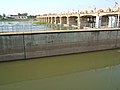
The Chao Phraya Dam is located in Tambon Bang Luang, Amphoe Sapphaya , southeast of Chai Nat on Highway 311. It is easy to reach from Highway 32 Bangkok - Nakhon Sawan . The length of the dam is 238 meters, the height of the dam is 14 meters. There are 16 water gates through which the Mae Nam Chao Phraya ( Chao Phraya River ) can pour out of the reservoir. A 14 meter wide lock is intended for navigation on the Chao Phraya.
use
Economic use
The Chao Phraya Dam serves as a catch basin for the excess water during the rainy season and thus ensures a certain reduction in the annual flooding in southern central Thailand.
In the rainy season , more than 2,300 m³ of water per second can flow off the Chao Phraya Dam.
power plant
The installed capacity of the power plant with two turbines is 12 MW . The annual production is 61.75 million kWh .
leisure
The area around the dam is very popular with the local population as an excursion destination. As a result, a golf course has also been built near the dam, operated by the Thai Irrigation Department.
Bird lovers also get their money's worth: many bird species liven up the landscape during the summer months, a number of which can be studied in the nearby Chai Nat (Bird Park).
Building history
The Chao Phraya Dam was the first major dam to be completed in Thailand . Construction began at the behest of King Bhumipol Adulyadej (Rama IX) in 1952 and lasted four years. In 1957 (the year 2500 according to the Buddhist calendar ) the system was switched on.
It cost about 1.4 billion baht to build .
Impressions
- Chao Phraya Dam at Chai Nat

View upstream

The lock
... seen from the side of the reservoir


See also
Web links
- Chainat interactive map. Retrieved April 1, 2007 (Interactive map of the Chai Nat province with the Chao Phraya Dam marked as a green barrier).
Individual evidence
- ↑ Patcharin Areewong: Flood update: Overall picture - Irrigation Department released water from dams to prepare for Changsan's landing ( Memento of the original from July 20, 2012 in the web archive archive.today ) Info: The archive link was inserted automatically and not yet checked. Please check the original and archive link according to the instructions and then remove this notice. Thai News, October 1, 2006, National News Bureau of Thailand
- ↑ Chao Phraya Dam. Electricity Generating Authority of Thailand (EGAT), accessed May 21, 2020 .