Kharkiv (river)
|
Kharkiv Kharkov |
||
| Data | ||
| location | Ukraine | |
| River system | Siversky Donets | |
| Drain over | Lopan → Udy → Siverskyi Donets → Don → Black Sea | |
| source | near Kriwenkow Jar in the Russian Oblast of Belgorod 50 ° 26 ′ 14 ″ N , 36 ° 26 ′ 24 ″ E |
|
| Source height | 160 m | |
| muzzle | near Kharkiv in the Lopan coordinates: 49 ° 59 ′ 7 ″ N , 36 ° 13 ′ 26 ″ E 49 ° 59 ′ 7 ″ N , 36 ° 13 ′ 26 ″ E
|
|
| length | 71 km | |
| Catchment area | 1160 km² | |
| Left tributaries | Murom , Nemyshlia | |
| Reservoirs flowed through | Trawjanske Reservoir | |
| Big cities | Kharkiv | |
| Communities | Lypzi , Zyrkuny , Vyaliw | |
|
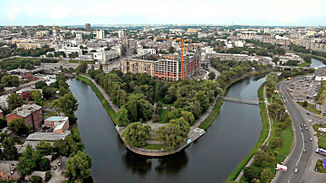
The mouth of the Kharkiv (right) and Lopan (left) in downtown Kharkiv |
||
The Kharkiv ( Ukrainian Харків ; Russian Харьков / Charkow ) is a 71 km long river in Russia and Ukraine . The river with a catchment area of 1160 km² is part of the Siverskyi Donets water system .
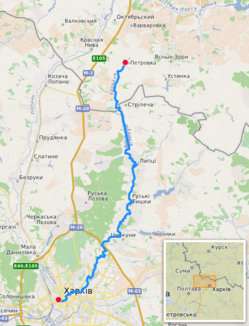
The Kharkiv rises near Kriwenkow Jar ( Кривеньков яр ) 5 kilometers east of the urban-type settlement Oktjabrski in the Russian Oblast Belgorod , then flows through the north of the Kharkiv Oblast , where it flows through the village of Lypzi to the 5.92 km² large Trawjanske Reservoir ( Трав ' янське водосховище ) before it flows into the Lopan from the left in the Ukrainian city of Kharkiv .
Tributaries
The longest tributaries of the Kharkiv are the Murom ( Муром ) rivers, which flow from the left, with a length of 35 km and a catchment area of 211 km², which is dammed to the Muromske Reservoir ( Муромське водосховище ; 4.08 km²) and the 27 km long Nemyschlja ( Немишля ) with a catchment area of 72 km². The Wjaliw , which also flows in from the left, is dammed up to the Wjaliwsk reservoir ( В'́ялівське водосховище ; 1.74 km²).
Web links
Individual evidence
- ↑ The Kharkiv River on znaimo.com , accessed October 2, 2015

