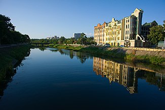
Lopan
|
Lopan Лопань |
||
|
The Lopan in Kharkiv 2011 |
||
| Data | ||
| location | Ukraine | |
| River system | Siversky Donets | |
| Drain over | Udy → Siverskyi Donets → Don → Black Sea | |
| source | near Wesjolaja Lopan in the Russian Oblast of Belgorod, 50 ° 29 ′ 25 ″ N , 36 ° 21 ′ 53 ″ E |
|
| Source height | 190 m | |
| muzzle | near Kharkiv in the Udy coordinates: 49 ° 56 ′ 13 ″ N , 36 ° 12 ′ 11 ″ E 49 ° 56 ′ 13 ″ N , 36 ° 12 ′ 11 ″ E
|
|
| length | 96 km | |
| Catchment area | 2000 km² | |
| Left tributaries | Kharkiv | |
| Big cities | Kharkiv | |
| Medium-sized cities | Derhatschi | |
| Small towns | Oktjabrski , Kosatscha Lopan , Slatyne , Mala Danyliwka | |
The Lopan ( Ukrainian and Russian Лопань ) is a 96 km long left tributary of the Udy in Russia and the Ukraine . The river with a catchment area of 2000 km² is part of the Siversky Donets water system .
Course of the Lopan |
The Lopan rises near Wesjolaja Lopan ( Russian Весёлая Лопань ) in the Russian Oblast Belgorod , then flows through the urban-type Oktjabrski (Russian Октябрьский ) settlement in the south of the oblast and then flows into the Ukraine. There it flows through the urban-type settlements Kosatscha Lopan and Slatyne , the city of Derhatschi and the SsT Mala Danyliwka in the north of the Ukrainian Oblast Kharkiv . In the center of the city of Kharkiv it takes the river Kharkiv ( Ukrainian Харків , 71 km length, catchment area 1160 km²) from the left and flows into the Udy in the south of the city.
Web links
Individual evidence
- ↑ description of the river on dozor.kharkov.ua; accessed October 1, 2015
- ↑ The Lopan River on retroua.com; accessed October 1, 2015

