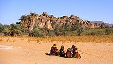
Chirfa
Location of Chirfa in Niger |
Chirfa is an oasis and the capital of the rural community of Djado in Niger .
The small oasis is located on the slope from Bilma to Djanet in Algeria or on the historic Bornus road . It is a starting point for exploring the Djado plateau with the ruined city of the same name. To the east of the run of the piste to the north is the Enneri Blaka , a valley cut in the plateau. The numerous rock paintings and prehistoric finds found in this area are significant . Rock formations such as the “submarine”, caves and rock bridges already offered protection in prehistoric times.
Chirfa had 260 inhabitants in the 1988 census, 208 inhabitants in the 2001 census and 288 inhabitants in the 2012 census. Members of the Tubu ethnic group live in the settlement .

The village consists of adobe houses surrounded by gardens. There is also a small school and sizable remains of a fort from the French colonial era . This fortification, called Fort Pacot, was built around 1913 and is named after a French sergeant who was killed in a fight with locals near the Orida waterhole near Chirfa in 1906. The facility was abandoned in 1914 and was reoccupied by a French garrison after the First World War.
In 1983 and 1984 the Dakar rally passed through Chirfa.
literature
- Maximilien Bruggmann, Hans Ritter: Ténéré. Through the southern Sahara . Bucher, Munich 1996, ISBN 3-7658-1078-9 .
Individual evidence
- ^ Republic of Niger: Loi n ° 2002-014 du 11 JUIN 2002 portant création des communes et fixant le nom de leurs chefs-lieux .
- ↑ Recensement Général de la Population 1988: Répertoire National des Villages du Niger . Bureau Central de Recensement, Ministère du Plan, République du Niger, Niamey March 1991, p. 35 ( ceped.org [PDF; accessed January 31, 2018]). www.ceped.org ( Memento of the original dated January 31, 2018 in the Internet Archive ) Info: The archive link was inserted automatically and has not yet been checked. Please check the original and archive link according to the instructions and then remove this notice.
- ^ Répertoire National des Communes (RENACOM). (RAR file) Institut National de la Statistique, accessed November 8, 2010 (French).
- ↑ Répertoire National des localites (ReNaLoc). (RAR) Institut National de la Statistique de la République du Niger, July 2014, p. 8 , accessed on 7 August 2015 (French).
- ↑ Harald A. Friedl: The justifiability of ethnotourism using the example of the Tuareg of the Agadez region, Republic of Niger (West Africa) - An evaluation from the perspective of applied tourism ethics. Dissertation . Karl Franzens University Graz, Graz 2005, p. 231 .
- ^ Saharan forts [2]. The 153 Club, accessed January 31, 2018 .
- ↑ Dakar Retrospective 1979–2007. (PDF) Amaury Sport Organization, archived from the original on July 8, 2011 ; accessed on February 14, 2018 (English).
Coordinates: 20 ° 57 ' N , 12 ° 20' E

