Bilma
| City of Bilma | ||
|---|---|---|
|
|
||
| Coordinates | 18 ° 41 ′ N , 12 ° 55 ′ E | |
| Basic data | ||
| Country | Niger | |
| Agadez | ||
| department | Bilma | |
| ISO 3166-2 | NE-1 | |
| height | 358 m | |
| Residents | 4409 (2012) | |
Bilma [ bilˈma ] (in Tuareg Berber Bălma ) is a municipality and the capital of the Bilma department of the same name in Niger .
geography
Bilma is an oasis town in the Kaouar Valley in the Ténéré desert . The neighboring communities are Dirkou in the north and east, N'Gourti in the south and Fachi in the west. The municipal area is divided into the four districts Djoulari, Jularie, Jularie et Boula and Quartier Administratif, the two administrative villages Aquer and Zoo Baba and the two hamlets Kourmossour and N'Gini Boulla.
climate
| Bilma | ||||||||||||||||||||||||||||||||||||||||||||||||
|---|---|---|---|---|---|---|---|---|---|---|---|---|---|---|---|---|---|---|---|---|---|---|---|---|---|---|---|---|---|---|---|---|---|---|---|---|---|---|---|---|---|---|---|---|---|---|---|---|
| Climate diagram | ||||||||||||||||||||||||||||||||||||||||||||||||
| ||||||||||||||||||||||||||||||||||||||||||||||||
|
Average monthly temperatures and rainfall for Bilma
Source: wetterkontor.de
|
|||||||||||||||||||||||||||||||||||||||||||||||||||||||||||||||||||||||||||||||||||||||||||||||||||||||||||||||||||||||||||||||||||||||||||||||||||||||||||||||||||||
history
The German Africa explorer Gerhard Rohlfs visited Bilma in 1866 and described the importance of the salt economy for the place.
In 1907, a district of Bilma was created in the French military territory of Niger . Its main town, however, was not the oasis of Bilma, but N'Guigmi on Lake Chad . It was not until 1911, in the course of an administrative reform in which the military territory was divided into six districts, that both N'Guigmi and Bilma became the capital of districts named after them.
In August 2006, Bilma was hit by a flood caused by the heaviest rainfall in the city since records began in 1923. More than 1,194 homes were destroyed and 4,369 people left homeless. For the people housed in makeshift accommodation, the situation became more difficult in the following months due to extreme temperature differences.
population
Bilma had 2,421 inhabitants at the 1988 census and 2,300 at the 2001 census. At the 2012 census, the population was 4,409. The majority of the population belongs to the Kanuri and Tubu ethnic groups . The spread in the community languages are the Kanuri - variety Bilma-Kanuri , the Tubu language Teda language and Libyan Arabic .
Economy and Infrastructure
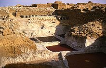
The small town lives from oasis economy , mainly from date palms, and the salt production , which has been practiced here since the 15th century. The Kalala salt pans are located about three kilometers northwest of the town center. Between the oasis and the salt pans, the dromedaries of the Sahara salt caravans are often stored in their thousands , which operate in the trans-Saharan trade from Bilma along the Bornus Strait to the south. The Bornus Strait is the connection from Tripoli through the Fessan and the Great Sand Desert from Bilma to Lake Chad . However, today's main route of the caravan trade has been running in an east-west direction for a long time and leads to Agadez and the Aïr Mountains .
Bilma is the seat of a military post and a Tribunal d'Instance, one of the 30 civil courts nationwide, which are below the ten civil courts of the first instance (Tribunal de Grande Instance). Customs and police stations and a post office are also available. An infrastructure for tourism, for example hotels, does not yet exist. As of 2003, there are only a few modest grocery stores, a bar and a restaurant available.
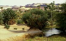
Bilma is an oasis with numerous shallow smaller lakes and streams leading to them. Numerous fish cavort in the waters. That was not always so. Only modern technology made it possible, because several wells have now been drilled from which water gushes under artesian pressure . There are some water taps in the village, the rest of the excess flows into the mentioned streams and ponds. This is a phenomenon in the entire Kaouar Valley: salt water and fresh water push upwards at small intervals. Due to the complex fracture tectonics in this part of the Ténéré desert, water penetrates from great depths through artesian pressure into sloping rock layers. Where it flows through salty layers from the Cretaceous period, it reaches the surface as a saline solution and, after being heavily reduced by evaporation, is used to produce salt. Otherwise, the date palms use the groundwater and therefore do not need any additional irrigation.
Personalities
- Chékou Koré Lawel (* 1957), General
- Fadjimata Sidibé (* 1955), educator, diplomat and politician
literature
- René Chudeau: Le cercle de Bilma . In: Geography . tape 21 , no. 4 , April 1910, p. 264-266 (French).
- Louis Desplagnes: Les oasis de la région de Bilma . In: Bulletin de la Société de Géographie de l'AOF . tape 2 , no. 30 , 1903, pp. 608-656; 740-794 (French).
- Louis Desplagnes: Notes on Bilma et les oasis environnants . In: Revue Coloniale . tape 7 , no. 51 , 1907, pp. 361-386 (French).
- Knut S. Vikør: The oasis of salt. The history of Kawar, a Saharan center of salt production . Center for Middle Eastern and Islamic Studies, Bergen 1999 (English).
Web links
Individual evidence
- ↑ Karl-G. Prasse, Ghoubeïd Alojaly, Ghabdouane Mohamed: Dictionnaire Touareg. Français (Niger): M – Ž . Museum Tasculanum Press, Copenhagen 2003, ISBN 87-7289-844-5 , p. 705 (French).
- ^ Répertoire National des Communes (RENACOM) . Website of the Institut National de la Statistique; Retrieved November 8, 2010.
- ^ Gerhard Rohlfs : Across Africa: Kauar and the Tebu in the Gutenberg-DE project
- ^ Gerhard Rohlfs: Across Africa . K. Thienemanns Verlag, Stuttgart / Vienna 1984, ISBN 3-522-60580-2 , chap. 9 (first edition: 1874).
- ↑ Edmond Séré de Rivières: Histoire du Niger . Berger-Levrault, Paris 1965, p. 236.
- ↑ Niger: Harsh Weather in Bilma DREF Operation No. MDRNE001 Final Report . International Red Cross and Red Crescent Movement , reliefweb.int June 13, 2008; Retrieved January 16, 2012.
- ↑ bevölkerungsstatistik.de: Page no longer available , search in web archives: Bilma , accessed on January 5, 2012.
- ↑ Presentation of the result globaux définitifs du Quatrième (4ème) Recensement Général de la Population et de l'Habitat (RGP / H) de 2012. (PDF) Institut National de la Statistique, 2014, accessed on April 18, 2014 (French).
- ↑ Niger map. In: Ethnologue : Languages of the World. Seventeenth edition. 2013, accessed on July 18, 2013 .
- ↑ Bachir Talfi: Note sur l'organization judiciaire . Nigerien Ministry of Justice website, accessed September 24, 2012.


