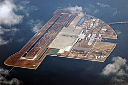
Chūbu airport
| Chūbu airport | |
|---|---|

|
|
| Characteristics | |
| ICAO code | RJGG |
| IATA code | NGO |
| Coordinates | |
| Height above MSL | 5 m (16 ft ) |
| Transport links | |
| Distance from the city center | 33 km from Nagoya |
| Street | 'Centrair Line' motorway |
| train | Meitetsu Tokoname Line |
| Basic data | |
| opening | February 17, 2005 |
| operator | CJIA Co., Ltd. |
| surface | 471 ha |
| Terminals | 1 |
| Passengers | 11,649,300 (2006) |
| Air freight | 306,957 t (2006) |
| Flight movements |
107,485 (2006) |
| Start-and runway | |
| 18/36 | 3500 m × 60 m |
The Chubu Airport ( Jap. 中部国際空港 , Chubu Kokusai Kuko ) often only Centrair ( セントレア , Sentorea called), is an airport located on an artificial island in Ise Bay , in the city of Tokoname on the Chita Peninsula , Aichi Prefecture , in Japan. It is located 33 kilometers south of the city of Nagoya and is the main airport in the Chūbu region. Chūbu Airport is a 1st class airport according to Japanese law .
It opened on February 17, 2005 and has the IATA airport code NGO and the ICAO airport code RJGG. Up until that day, Nagoya Airport was the main airport in central Japan.
Lufthansa flies to the airport from Frankfurt / Main once a day with an Airbus A340-300.
Individual evidence
- ↑ a b c ACI ( Memento of the original from February 22, 2016 in the Internet Archive ) Info: The archive link was automatically inserted and not yet checked. Please check the original and archive link according to the instructions and then remove this notice.
Web links
Commons : Central Japan International Airport - Collection of pictures, videos and audio files
- Centrair Homepage (English)
- Centrair Homepage (Japanese)
