Citlaltépetl
| Citlaltépetl Pico de Orizaba |
||
|---|---|---|
| height | 5636 m | |
| location | Border states Puebla / Veracruz , Mexico | |
| Dominance | 2,690.14 km → Mount Logan | |
| Notch height | 4922 m | |
| Coordinates | 19 ° 1 ′ 49 ″ N , 97 ° 16 ′ 11 ″ W | |
|
|
||
| Type | Stratovolcano | |
| rock | Andesite , dacite | |
| Age of the rock | Middle Pleistocene to Holocene | |
| Last eruption | 1846 | |
| First ascent | May 10, 1848 by F. Maynard and G. Reynolds | |
| Normal way | Alpine tour, glaciated | |
| particularities | Highest volcano in North America and highest mountain in Mexico | |
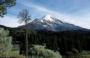
The Citlaltépetl (also called Pico de Orizaba ) is the highest volcano in North America and the highest mountain in Mexico with a height of 5636 m . Its summit, which is snow-covered into the summer, is visible to ships in the Gulf of Mexico from a distance of 110 km on - rare - clear days .
Toponyms
The name Citlaltépetl means something like 'mountain of the star' and is a combination of the Nahuatl words citlalli ('star') and tepetl ('mountain'). Another local name is Iztactépetl , which means 'White Mountain'. However, this is also a synonym for the Iztaccíhuatl .
location
The mountain lies on the border between the Mexican states of Veracruz and Puebla, north of the city of Orizaba, which has around 120,000 inhabitants . The Río Jamapa rises in its eastern foothills .
Volcanic activity
A severe eruption occurred in 1566. Further eruptions occurred in 1537, 1569, 1613 and 1630. The most recent known eruption dates from 1846. After centuries of silence, fumaroles were last seen again in 2010 at Citlaltépetl , which were the first signs for a new phase of activity.
history
The first ascent took place in 1848 by F. Maynard and G. Reynolds. The mountain has been a national park since 1937. In 1959 three climbers disappeared. In 2015, two mummified climbers were found who have yet to be identified.
The Large Millimeter Telescope was built in 2007 on the neighboring Sierra Negra summit .
In the vicinity of the mountain is also the High Altitude Water Cherenkov Observatory (HAWC), a research facility for the detection of cosmic rays and extraterrestrial gamma rays with the help of the Cherenkov radiation effect .
photos
See also
Other volcanic mountains of the Sierra Volcánica Transversal Mexico are: Popocatépetl ( 5426 m ), Iztaccíhuatl ( 5230 m ), Nevado de Toluca ( 4680 m ) and Sierra Negra ( 4621 m ).
Remarks
- ↑ Highest mountain in Mexico: mountaineers find mummified corpses. In: Spiegel Online . March 6, 2015, accessed June 9, 2018 .
Web links
- Citlaltépetl in the Global Volcanism Program of the Smithsonian Institution (English)
- Citlaltépetl on Peakbagger.com (English)


