Coari
| Município de Coari "Terra do Gás"
Coari
|
|||
|---|---|---|---|
|
|
|||
| Coordinates | 4 ° 5 ′ S , 63 ° 8 ′ W | ||
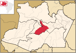
 Location of the municipality in the state of Amazonas Location of the municipality in the state of Amazonas
|
|||
| Symbols | |||
|
|||
| founding | May 1, 1874 (Vila de Coari) (146 years old) |
||
| Basic data | |||
| Country | Brazil | ||
| State | Amazon | ||
| ISO 3166-2 | BR-AM | ||
| structure | 5 districts | ||
| surface | 57,970.8 km² | ||
| Residents | 75,965 (2010) | ||
| density | 1.3 Ew. / km² | ||
| estimate | 85.097 (July 1, 2019) | ||
| Parish code | IBGE : 1301209 | ||
| Post Code | 69460-000 | ||
| Telephone code | (+55) 97 | ||
| Time zone | UTC −4 | ||
| Website | coari.am (Brazilian Portuguese) | ||
| politics | |||
| City Prefect | Adail Jose Figueiredo Pinheiro (2017-2020) | ||
| Political party | Progressistas (PP) | ||
| economy | |||
| GDP | 1,320,621 thousand R $ 15,580 R $ per person (2017) |
||
| HDI | 0.586 (low) (2010) | ||
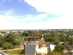
Coari , officially Município de Coari , is a Brazilian municipality in the state of Amazonas . The city is the seat of the Roman Catholic Diocese of Coari . The population was estimated on July 1, 2019 at 85,097 inhabitants, who are called Coarienses ( Coarienses ) and live in a municipal area of around 57,971 km² (2019). The distance to the capital Manaus is 363 km.
There are several nature reserves in the municipality.
The township of Coari is one of the largest cities in the state of Amazonas. The area has oil and natural gas reserves. Coari is served by Coari Airport, 6 km from downtown Coari . The airport Porto Urucu in the 470-km away Porto Urucu region called the population that serves for Petrobras operates.
The core of the settlement was a foundation on Lake Coari by the Bohemian Jesuit missionary Samuel Fritz at the beginning of the 18th century. In the 19th century, the municipality was under the administration of Tefé , received city rights as Vila de Coari on May 1, 1874 and was spun off from Tefé. The large municipal area is divided into districts: Distrito de Coari , also the seat of the municipality, Distrito de Camará , Distrito de Barro Alto , Distrito de Copiá and Distritro de Peorini .
Some of the population speaks the dialect Amazofonia , also known as Nortista.
Attractions
sons and daughters of the town
- Silvério José Nery (1858–1934), former governor of the Amazon
Web links
- City Prefecture website , Prefeitura Municipal (Brazilian Portuguese)
- City Council website , Câmara Municipal (Brazilian Portuguese)
- Cultura Coariense
- Atlas do Desenvolvimento no Brasil: Coari , demographic information (Brazilian Portuguese)
Individual evidence
- ↑ a b c Coari - Panorama. IBGE , accessed July 27, 2020 (Brazilian Portuguese).
- ^ Adail Filho 11 (Prefeito). In: todapolitica.com. Eleições 2016, accessed July 31, 2020 (Brazilian Portuguese).


