Colstrip
| Colstrip | |
|---|---|
| Nickname : Tomorrow's Town Today | |
 Welcome sign at the local border |
|
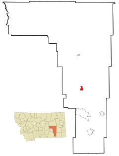
| Location in Montana | |
| Basic data | |
| Foundation : | 1998 |
| State : | United States |
| State : | Montana |
| County : | Rosebud County |
| Coordinates : | 45 ° 53 ′ N , 106 ° 37 ′ W |
| Time zone : | Mountain ( UTC − 7 / −6 ) |
| Residents : | 2,214 (as of 2010) |
| Population density : | 191.2 inhabitants per km 2 |
| Area : | 11.58 km 2 (approx. 4 mi 2 ) of which 11.58 km 2 (approx. 4 mi 2 ) is land |
| Height : | 982 m |
| Postal code : | 59323 |
| Area code : | +1 406 |
| FIPS : | 30-16525 |
| GNIS ID : | 0770042 |
| Website : | http://www.cityofcolstrip.com/ |
| Mayor : | John Williams |
Colstrip is a city in the US state of Montana , United States and the largest city in Rosebud County . The most important industries are hard coal mining and power generation .
For its 50th anniversary, the US sports magazine Sports Illustrated named Colstrip the top sports city of Montana.
geography
Colstrip is located in the south of Montana and extends over an area of 11.58 km².
In 2010 the population was 2214.
history
Colstrip was founded in 1924 as a workers' settlement that was supposed to provide coal for the steam locomotives of the Northern Pacific Railway . The coal was mined by opencast mining.
During World War II , coal from the Colstrip mine was used to enable the Northern Pacific Railway's locomotives to transport military equipment. Since the mine was given an important strategic task, it was guarded to avoid acts of sabotage. The workers were also not allowed to quit their jobs at the time.
When the railroad only used diesel locomotives from 1958 , the Rosebud Mine in Colstrip was closed. In 1959, the Montana Power Company , an electricity company, bought the rights to the mine and resumed operations in the 1970s with the aim of building coal-fired power plants in Colstrip.
In the 1970s and 1980s, the power plants were built by various companies such as the Bechtel Corporation . During this time Colstrip experienced a boom, which was noticeable in a sharp increase in the population. Power plants 1 and 2 became operational in 1975 and 1976, respectively, and power plants 3 and 4 in 1984 and 1986.
In 1974 Castle Rock Lake was completed. It is used to store the water for the four power plants. The water is transported here from the Yellowstone River via a 30 mile underground pipeline . The lake has become the habitat of numerous animals.
The power plants 1–4 were sold to the energy company PPL in 1998 , the Rosebud Mine was sold by Westmoreland Mining LLC. acquired. In the same year Colstrip was incorporated.
- Construction of the power stations in Colstrip
Individual evidence
- ↑ Colstrip homepage, as of May 2019
- ↑ Sports Illustrated (English) ( Memento of 4 June 2011 at the Internet Archive )
- ↑ United States Census Bureau (English)
Web links
- Official Website of Colstrip (English)


