Coromandel Harbor
| Coromandel Harbor | ||
| Geographical location | ||
|
|
||
| Coordinates | 36 ° 47 ′ S , 175 ° 29 ′ E | |
| Region ISO | NZ-WKO | |
| country | New Zealand | |
| region | Waikato | |
| Sea access | Hauraki Gulf , Pacific Ocean | |
| Data on the natural harbor | ||
| Port entrance | 1 343 m wide | |
| length | around 6.5 km | |
| width | max 6.5 km | |
| Coastline | around 30 km | |
| places | Coromandel | |
| Tributaries | Waiau River and numerous streams (brooks) | |
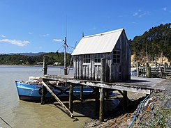
| Jetty | Coromandel Wharf on McGregor Bay , Te Kouma and the Sugarloaf Wharf in the southern area, | |
| Photography of the natural harbor | ||
 Coromandel Wharf in the northern area of the natural harbor |
||
Coromandel Harbor is a natural harbor on the Coromandel Peninsula on the North Island of New Zealand .
geography
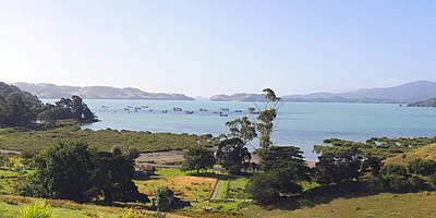
The Coromandel Harbor is located on the west coast of the Coromandel Peninsula , about 40 km north of the Thames . The place Coromandel is located at the northeast end of the natural harbor, which extends in both directions over a maximum of 6.5 km and has a coastline of around 30 km.
The Ruffin Peninsula and Whanganui Island close the Coromandel Harbor to the Hauraki Gulf , not without leaving two points of access. All shipping traffic passes through the southwest port entrance, which is 1343 m wide. The second port entrance, located between Whanganui Island and Ruffin Peninsula , is only 60 m wide and is not suitable for larger boats and ships due to its silting.
use
Oysters are raised in mussel farms at various points in the natural harbor .
Planned port expansion
An expansion has been planned for the Coromandel Wharf and Sugarloaf Warf facilities since 2014 . While Sugarloaf Wharf is to be expanded for industrial use, the development of Coromandel Wharf as both a marina and a commercial port is being considered. Other extensions such as boat ramps and park and ride facilities were also in the planning stage. As of December 2017, the project was still in the planning and decision-making phase.
See also
Web links
- Paul Monin : Traders and Māori at Coromandel Harbor, around 1848 . In: Te Ara - the Encyclopedia of New Zealand . Ministry for Culture & Heritage , accessed on January 22, 2018 (English, scene at the harbor, watercolor by Joseph Jenner Merrett).
Individual evidence
- ↑ Topo250 maps . Land Information New Zealand , accessed January 22, 2018 .
- ↑ Coordinates and longitudes were partly made using Google Earth version 7.1.8.3036 on January 22, 2018.
- ^ Coromandel Harbor Facilities Project . Thames Coromandel District Council , accessed January 22, 2018 .
- ^ Coromandel Harbor Project Milestone Dates . Thames Coromandel District Council , accessed January 22, 2018 .

