Craigeam
| Craigeam | ||
|---|---|---|
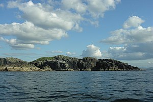
| View of Craigeam; the cape on the left belongs to Lewis | ||
| Waters | North Atlantic | |
| Archipelago | Outer Hebrides | |
| Geographical location | 58 ° 17 '8 " N , 6 ° 49' 56" W | |
|
|
||
| length | 270 m | |
| width | 270 m | |
| Highest elevation | 37 m ASL | |
| Residents | uninhabited | |
Craigeam is a Scottish island in the Outer Hebrides . It is located in the council area of the same name and was historically part of the traditional county of Ross-shire or the administrative county of Ross and Cromarty .
A cairn on the uninhabited island is more recent.
geography
Craigeam is located at the northeast entrance of Loch Roag Bay and its subsidiary bay Loch Carloway off the west coast of the Isle of Lewis . It is only separated from the main island of Lewis by a waterway around 200 meters wide. The opposite Cape on Lewis is equipped with a beacon .
The rugged rock island is about 2.5 kilometers northeast, east-northeast and east of the neighboring islands of Little Bernera , Kealasay and Campay . The rocks Cul Chraigeam and Sgeir Dhearg Cul Chraigeam are just in front of the north . The closest settlement on Lewis is Carloway, four kilometers east .
The rock island has a maximum length and width of 270 meters each. Its highest point rises 37 meters above sea level.
Individual evidence
- ^ A b c Information in the Gazetteer for Scotland
- ↑ Entry on Craigeam in Canmore, the database of Historic Environment Scotland (English)
- ↑ a b c Measurement of Google Maps
- ↑ Entry on Laimishader in Canmore, the database of Historic Environment Scotland (English)
- ^ Map of the Ordnance Survey

