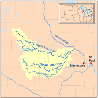
Crow River, Minnesota
| Crow River | ||
| Data | ||
| Water code | US : 642502 | |
| location | Minnesota , USA | |
| River system | Mississippi River | |
| Drain over | Mississippi River → Gulf of Mexico | |
| origin | The confluence of the North and South Fork Crow Rivers in Hennepin County at Rockford 45 ° 4 ′ 53 ″ N , 93 ° 45 ′ 45 ″ W |
|
| muzzle | in Wright County , Mississippi Coordinates: 45 ° 14 ′ 45 " N , 93 ° 31 ′ 21" W 45 ° 14 ′ 45 " N , 93 ° 31 ′ 21" W
|
|
| length | 39.9 km | |
|
Crow River at Rockford |
||
| North Fork Crow River | ||
| Water code | US : 648637 | |
| source | in Pope County 45 ° 36 ′ 7 ″ N , 95 ° 10 ′ 16 ″ W.
|
|
| length | 253.4 km | |
| Right tributaries | Middle Fork Crow River | |
| Middle Fork Crow River | ||
| Water code | US : 647809 | |
| source | in Stearns County 45 ° 26 ′ 5 ″ N , 94 ° 59 ′ 11 ″ W. |
|
| muzzle | in Meeker County in the North Fork 45 ° 15 ′ 9 ″ N , 94 ° 36 ′ 8 ″ W
|
|
| length | 72.6 km | |
| South Fork Crow River | ||
| Water code | US : 663175 | |
| source | in Kandiyohi County 45 ° 3 ′ 26 " N , 94 ° 55 ′ 18" W
|
|
| length | 186.7 km | |
|
Salisbury Bridge at Kingston |
||
The Crow River in Minnesota , northwest of the Minneapolis-Saint Paul metropolitan area , is a right tributary of the Mississippi River .
course
Most of the entire course consists of 3 arms.
- The North Fork Crow River is 253.4 km long. It flows through Pope County first , then Stearns County , Kandiyohi County , Meeker County, and Wright County .
- The Middle Fork Crow River is 45 miles long. It comes from Stearns County, then flows through Kandiyohi County and flows into the North Fork Crow River in Meeker County.
- The South Fork Crow River is 186.7 km long. It flows through Kandiyohi County first, then Meeker County, McLeod County , Carver County, and Wright County. Some sections of the upper reaches have been straightened and channeled. At Rockford it flows into the North Fork Crow River, creating the actual Crow River, which flows into the Mississippi River after 39.9 km. The course of the river forms a boundary between Wright County and Hennepin County .
Fish fauna
The most common fish species is Moxostoma macrolepidotum , the second most common is the spotted catfish . Glass eye bass and black bass are far less common, but occasionally remarkably large specimens are caught.
Worth seeing
Salisbury Bridge a few miles west of Kingston is a truss steel bridge listed as No. 90980 on the National Register of Historic Places . The bridge was built in 1899 and connects Kingston with Forest City Township as part of a dirt road. The name of the bridge refers to a farmer named Salisbury, who lived near the bridge and who worked for the Minnesota House of Representatives at times. The bridge type was invented in 1844 by engineers Thomas Willis Pratt and his father. This type of bridge, which was used in the United States for spans up to 76 m until the early 20th century, was part of the transition from wood to metal.
Individual evidence
- ^ A b c d e Charles Henry Prior: Water Resources of the Minneapolis-St. Paul Area, Minnesota, 1953, pp. 25ff
- Jump up ↑ Sportsman's Connection: Minnesota - West Metro Area Fishing Map Guide, 2016, p. 222
- ↑ Minnesota Department of Transportation - Salisbury Bridge (Bridge 90980)
- ^ Jacob Lubliner, Panayiotis Papadopoulos: Introduction to Solid Mechanics - An Integrated Approach, 2016, p. 116


