Cut bench
| Cut bench | |
|---|---|
 Glacier County Courthouse in Cut Bank |
|
| Location in Montana | |
| Basic data | |
| State : | United States |
| State : | Montana |
| County : | Glacier County |
| Coordinates : | 48 ° 38 ′ N , 112 ° 20 ′ W |
| Time zone : | Mountain ( UTC − 7 / −6 ) |
| Residents : | 2,869 (as of 2010) |
| Population density : | 1,120.7 inhabitants per km 2 |
| Area : | 2.56 km 2 (approx. 1 mi 2 ) of which 2.56 km 2 (approx. 1 mi 2 ) is land |
| Height : | 1150 m |
| Postal code : | 59427 |
| Area code : | +1 406 |
| FIPS : | 30-18775 |
| GNIS ID : | 0770395 |
| Website : | www.cityofcutbank.org |
| Mayor : | Doug Embody |
Cut Bank is a city in Montana , United States . The administrative seat of the Glacier County has about 2900 inhabitants.
The name of the city refers to a slope ( English Cut bank ), which the Cut Bank Creek formed near the city.
geography
Cut Bank is located in northwest Montana, approximately 30 miles south of the Canadian border. The urban area has a size of 2.56 km².
Just outside of town is a canyon through which Cut Bank Creek flows. This is spanned by a railway bridge that leads elevated over the stream.
In 2010 the population was 2,869.
Infrastructure
Cut Bank is served daily by Amtrak's Empire Builder long-distance train on its route from Chicago to Seattle . Before that, Cut Bank was already on the route network of an Empire Builder train from Amtrak's predecessor, the Great Northern Railway .
Of the twelve Amtrak stations in Montana, Cut Banks was the second-poorest in terms of traffic in fiscal 2010, with an average of 9 people getting on or off the bus every day.
Cut Bank is also home to an important freight yard for the BNSF Railway , where three grain elevators collect grain from the western Great Plains .
While the station, platform and parking lot belong to Amtrak, the BNSF Railway owns the tracks and signal systems.
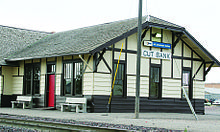
In association with Amtrak and the BNSF Railway, Cut Bank's historic train station was recently repainted in traditional colors.
The municipal airport is located 6 km southwest of Cut Bank. This was used for exercises by the Second Air Force during World War II and is now mainly used by general aviation .
Cut Bank is on US Highway 2 , which runs east-west from Everett , Washington to Houlton , Maine across the north of the United States .
climate
Due to the semi-arid climate , the winters in Wolf Point are usually cold and dry, while the short summers are warm.
| Cut Bank Municipal Airport, Montana | ||||||||||||||||||||||||||||||||||||||||||||||||
|---|---|---|---|---|---|---|---|---|---|---|---|---|---|---|---|---|---|---|---|---|---|---|---|---|---|---|---|---|---|---|---|---|---|---|---|---|---|---|---|---|---|---|---|---|---|---|---|---|
| Climate diagram | ||||||||||||||||||||||||||||||||||||||||||||||||
| ||||||||||||||||||||||||||||||||||||||||||||||||
|
Average monthly temperatures and rainfall for Cut Bank Municipal Airport, Montana
Source: National Oceanic and Atmospheric Administration (PDF; 765 kB)
|
|||||||||||||||||||||||||||||||||||||||||||||||||||||||||||||||||||||||||||
history
On July 26, 1806, Meriwether Lewis camped here with eight Blackfeet Indians . The meeting was cheerful at first, before Lewis revealed to the Indians that the US was planning to equip all Plains Indians with firearms for hunting. This was not good news for the Blackfeet because they had previously controlled the guns through trade with the Hudson's Bay Company. Then there was a fight in which two Indians were killed.
The almost 1,300 km long Cherokee Trail , which began in Fort Smith , ended in Cut Bank . It was built in the 1850s and 1860s by Cherokee miners who wanted to come to Colorado , Wyoming and California because of the gold rush .
sons and daughters of the town
- Gerard Jones (* 1957), writer and comic book author
References in popular culture
- The last song on the album Maverick of Hank Williams Jr. 's Cut Bank Montana .
- 2014 saw the release of Cut Bank, a feature film set in Cut Bank, directed by Matt Shakman .
Individual evidence
- ↑ United States Census Bureau (English)
Web links
- Official website of Cut Bank (English)
- Website of the Chamber of Commerce of Cut Bank (English)


