Daniëlskuil
| Daniëlskuil | ||
|---|---|---|
|
|
||
| Coordinates | 28 ° 11 ′ S , 23 ° 33 ′ E | |
| Basic data | ||
| Country | South Africa | |
| North Cape | ||
| District | ZF Mgcawu | |
| ISO 3166-2 | ZA-NC | |
| local community | Kgatelopele | |
| height | 1469 m | |
| surface | 174.6 km² | |
| Residents | 13,597 (2011) | |
| density | 77.9 Ew. / km² | |
|
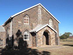
Second Dutch Reformed Church
|
||
Daniëlskuil , also Danielskuil , is a place in the South African province of Northern Cape . It is the administrative seat of the municipality of Kgatelopele in the ZF Mgcawu district .
geography
Daniëlskuil has 13,597 inhabitants (as of 2011) who live on over 170 square kilometers. 63 percent said Afrikaans was the main language used, 31 percent named Setswana . The place is east of the 1800 meter high Asbestos Mountains , also called Kuruman Hills. The climate is arid , but the environment is quite fertile, so that it is counted as part of the "Green Kalahari ".
After Kimberley in the southeast there are around 160 kilometers of Postmasburg in the west 70 km.
history
At the beginning of the 19th century, Griqua ruled the region. At today's location there was a six-meter-deep pit in the dolomite rock where snakes lived. The Griqua leader Adam Kok II is said to have used it as a prison. In 1816 a missionary first reached the place he called Fraaifontein; In 1820 another missionary named the place after Daniel's Den , Afrikaans Daniëlskuil; German: " Daniels Löwengrube " (see Dan 6,1 f. EU ). In 1892 the place was officially recognized. In 1942, the lung disease asbestosis , which is caused by inhalation of asbestos , was detected here for the first time .
Economy and Transport
Limestone , diamonds , asbestos and marble are mined near the place . Immediately south of the town is the Idwala Mine , which began in 1974 and produces around five million tons of limestone every year. Asbestos is mined in the Asbestos Mines southwest of the city. Diamonds are mined in the Finsch Diamond Mine south of Lime Acres - a town south of Daniëlskuil. In addition, livestock is farmed around Daniëlskuil.
Daniëlskuil is on the R31 , which leads from Kuruman in the north to Barkly West in the east, and on the R385, which connects Postmasburg in the west with Douglas in the south - the two roads bend at right angles. The city is also the terminus of a branch line that is used for freight traffic and connects to the Sishen –Kimberley freight line , which connects to numerous other mines.
Daniëlskuil Airport is located in the west of the city and is not served by scheduled flights.
Attractions
In the center are two church buildings of the Dutch Reformed Church .
About 30 kilometers away is Boesmansgat, the second deepest sinkhole in the world at almost 300 meters . It is the target of recreational divers .
Web links
- Daniëlskuil at showme.co.za (English)
Individual evidence
- ↑ a b 2011 Census , accessed on December 22, 2017
- ↑ a b c d Danielskuil at sa-venues.com (English), accessed on December 22, 2017
- ↑ Danielskuil at greenkalahari.com (English), accessed on December 23, 2017
- ↑ Daniëlskuil at showme.co.za (English), accessed on December 23, 2017

