Les Hauts de Forterre
| Les Hauts de Forterre | ||
|---|---|---|
|
|
||
| region | Bourgogne-Franche-Comté | |
| Department | Yonne | |
| Arrondissement | Auxerre | |
| Canton | Vincelles | |
| Community association | Puisaye-Forterre | |
| Coordinates | 47 ° 37 ' N , 3 ° 24' E | |
| height | 224-386 m | |
| surface | 33.07 km 2 | |
| Residents | 509 (January 1, 2017) | |
| Population density | 15 inhabitants / km 2 | |
| Post Code | 89560 | |
| INSEE code | 89405 | |
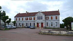
 Town hall of Les Hauts de Forterre |
||
Les Hauts de Forterre is a French municipality with 509 inhabitants (as of January 1 2017) in the department of Yonne in the region Bourgogne Franche-Comté ; it belongs to the arrondissement of Auxerre . The municipality belongs to the canton of Vincelles .
geography
Les Hauts de Forterre is about 25 kilometers southwest of Auxerre . Les Hauts de Forterre is surrounded by the neighboring communities of Ouanne in the north, Merry-Sec in the northeast, Courson-les-Carrières in the east, Druyes-les-Belles-Fontaines in the south, Sougères-en-Puisaye in the southwest and Sementron in the west and northwest .
structure
| District | former INSEE code |
Area (km²) | Population (2017) |
|---|---|---|---|
| Fontenailles | 89174 | 2.76 | 68 |
| Molesmes | 89260 | 9.50 | 176 |
| Taingy (administrative headquarters) | 89405 | 20.81 | 265 |
Attractions
- Saint-Martin church in Taingy, monument historique since 1926
- Saint-Léger church in Fontenailles
- Notre-Dame Church of Molesmes, Monument historique
Web links
Commons : Les Hauts de Forterre - Collection of images, videos and audio files


