
Etais-la-Sauvin
| Etais-la-Sauvin | ||
|---|---|---|
.svg)
|
|
|
| region | Bourgogne-Franche-Comté | |
| Department | Yonne | |
| Arrondissement | Auxerre | |
| Canton | Vincelles | |
| Community association | Puisaye-Forterre | |
| Coordinates | 47 ° 30 ' N , 3 ° 21' E | |
| height | 178-365 m | |
| surface | 44.79 km 2 | |
| Residents | 629 (January 1, 2017) | |
| Population density | 14 inhabitants / km 2 | |
| Post Code | 89480 | |
| INSEE code | 89158 | |
 Town hall (Mairie) of Étais-la-Sauvin |
||

Étais-la-Sauvin is a French municipality with 629 inhabitants (as of January 1 2017) in the department of Yonne in the region Bourgogne Franche-Comté . It belongs to the canton of Vincelles in the Auxerre arrondissement . The inhabitants are called Étaisiens .
geography
Étais-la-Sauvin is located about 26 kilometers south-southwest of Auxerre . Étais-la-Sauvin is surrounded by the neighboring communities are Sougères-en-Puisaye in the north, Druyes-les-Belles-Fontaines in the east and northeast, Billy-sur-Oisy in the south and southeast, Entrains-sur-Nohain in the south and southwest , Sainpuits in the west and Lainsecq in the northwest.
Population development
| year | 1962 | 1968 | 1975 | 1982 | 1990 | 1999 | 2006 | 2013 |
| Residents | 954 | 882 | 787 | 754 | 696 | 692 | 705 | 663 |
| Source: Cassini and INSEE | ||||||||
Attractions
- Saint-Pierre-aux-Liens church, Monument historique
- Chapel of Sainte-Camille
- Fortification of Étais-la-Sauvin
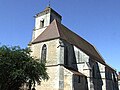
Saint-Pierre-aux-Liens church
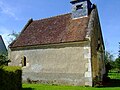
Chapel of Sainte-Camille


Web links
Commons : Étais-la-Sauvin - collection of images, videos and audio files