
Montholon (Yonne)
| Montholon | ||
|---|---|---|
|
||
| region | Bourgogne-Franche-Comté | |
| Department | Yonne | |
| Arrondissement | Auxerre | |
| Canton | Charny | |
| Community association | Aillantais | |
| Coordinates | 47 ° 53 ' N , 3 ° 21' E | |
| height | 85-241 m | |
| surface | 50.08 km 2 | |
| Residents | 2,866 (January 1, 2017) | |
| Population density | 57 inhabitants / km 2 | |
| Post Code | 89110, 89710 | |
| INSEE code | 89003 | |

Montholon is a French commune with 2,866 inhabitants (as of January 1 2017) in the department of Yonne in the region Bourgogne Franche-Comté ; it belongs to the arrondissement of Auxerre . The municipality belongs to the canton of Charny .
geography
Montholon is about 20 kilometers northwest of Auxerre on the Tholon . Montholon is surrounded by the neighboring communities of Béon and Chamvres in the north, Paroy-sur-Tholon , Champlay and Senan in the northeast, Valravillon in the east, Poilly-sur-Tholon in the southeast, Chassy in the south, La Ferté-Loupière in the west and Sépeaux-Saint Romain to the west and northwest.
The A6 autoroute runs through the municipality .
structure
| District | former INSEE code |
Area (km²) | Population (2017) |
|---|---|---|---|
| Aillant-sur-Tholon (administrative headquarters) | 89003 | 18.20 | 1,404 |
| Champvallon | 89078 | 6.83 | 643 |
| Villiers-sur-Tholon | 89473 | 15.50 | 469 |
| Volgré | 89484 | 9.55 | 350 |
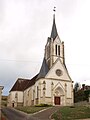
Attractions
- Saint-Martin church in Aillant-sur-Tholon, a historic monument since 1987
- Champvallon Church
- Saint-Jean-Baptiste church in Villiers-sur-Tholon, a historic monument since 1976
- Church of Volgré

Saint Martin Church
Champvallon Church

Saint-Jean-Baptiste church

Church of Volgré


