Toucy (Yonne)
| Toucy | ||
|---|---|---|

|
|
|
| region | Bourgogne-Franche-Comté | |
| Department | Yonne | |
| Arrondissement | Auxerre | |
| Canton | Cœur de Puisaye (main town) | |
| Community association | Puisaye-Forterre | |
| Coordinates | 47 ° 44 ′ N , 3 ° 18 ′ E | |
| height | 177-306 m | |
| surface | 34.85 km 2 | |
| Residents | 2,662 (January 1, 2017) | |
| Population density | 76 inhabitants / km 2 | |
| Post Code | 89130 | |
| INSEE code | 89419 | |
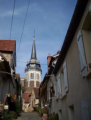
 Ruelle de Toucy lane leads to the Saint-Pierre church |
||
Toucy is a French commune in the Yonne department in the region of Bourgogne Franche-Comté ; it belongs to the Arrondissement of Auxerre and the canton of Cœur de Puisaye . The surrounding landscape is known as Puisaye .
geography
The place is 25 kilometers southwest of Auxerre , on the banks of the Ouanne River .
history
In Gallo-Roman times the place was called Toutiacus. Because of its border location, Toucy was long disputed between the king and the Duchy of Burgundy . Therefore the church was fortified and looks more like a castle than a house of God.
Population development
| 1962 | 1968 | 1975 | 1982 | 1990 | 1999 | 2006 |
|---|---|---|---|---|---|---|
| 2,417 | 2,505 | 2,584 | 2,665 | 2,590 | 2,602 | 2,669 |
Community partnerships
Toucy has had a community partnership with Kusel in Rhineland-Palatinate since 1973 .
Personalities
- Gilo of Paris , medieval poet and cardinal-bishop of Tusculum
- Pierre Larousse
- Jochen Hartloff , German politician and honorary citizen of Toucy
Web links
Commons : Toucy - collection of images, videos and audio files
