
Le Val d'Ocre
| Le Val d'Ocre | ||
|---|---|---|
|
||
| region | Bourgogne-Franche-Comté | |
| Department | Yonne | |
| Arrondissement | Auxerre | |
| Canton | Charny | |
| Community association | Aillantais | |
| Coordinates | 47 ° 49 ′ N , 3 ° 19 ′ E | |
| height | 135-267 m | |
| surface | 29.47 km 2 | |
| Residents | 566 (January 1, 2017) | |
| Population density | 19 inhabitants / km 2 | |
| Post Code | 89110 | |
| INSEE code | 89334 | |

Le Val d'Ocre is a French municipality with 566 inhabitants (as of January 1 2017) in the department of Yonne in the region Bourgogne Franche-Comté ; it belongs to the arrondissement of Auxerre . The municipality belongs to the canton of Charny .
On January 1, 2016, Le Val d'Ocre was formed as Commune nouvelle from the previously independent communities of Saint-Aubin-Château-Neuf and Saint-Martin-sur-Ocre .
geography
Le Val d'Ocre is about 25 kilometers west-northwest of Auxerre . Le Val d'Ocre is surrounded by the neighboring communities of Les Ormes in the north, Chassy in the north and northeast, Saint-Maurice-Thizouaille and Saint-Maurice-le-Vieil in the east, Égleny in the southeast, Merry-la-Vallée in the south, and Villiers -Saint-Benoît to the west and south-west and Sommecaise to the west and north-west.
structure
| District | former INSEE code |
Area (km²) | Population (2016) |
|---|---|---|---|
| Saint-Aubin-Château-Neuf (administrative headquarters) | 89334 | 24.89 | 520 |
| Saint-Martin-sur-Ocre | 89356 | 4.58 | 53 |
Attractions
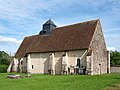
- Saint-Aubin-et-Saint-Léonard church in Saint-Aubin-Château-Neuf from the 15th century, Monument historique
- Notre-Dame-de-Pitié church
- Castles in Saint-Aubin-Château-Neuf
- Fourolles Castle
- Beaurin Castle
- Froville Castle
- Fumerault Castle
- Sculpture path in Saint-Aubin-Château-Neuf

Saint-Aubin-et-Saint-Léonard church
Notre-Dame-de-Pitié church

Fourolles Castle


Web links
Remarks
- ↑ Population figures retrospectively from January 1, 2016