Monéteau
| Monéteau | ||
|---|---|---|

|
|
|
| region | Bourgogne-Franche-Comté | |
| Department | Yonne | |
| Arrondissement | Auxerre | |
| Canton | Auxerre-2 | |
| Community association | Auxerrois | |
| Coordinates | 47 ° 51 ′ N , 3 ° 35 ′ E | |
| height | 88-181 m | |
| surface | 18.19 km 2 | |
| Residents | 3,985 (January 1, 2017) | |
| Population density | 219 inhabitants / km 2 | |
| Post Code | 89470 | |
| INSEE code | 89263 | |
| Website | http://www.moneteau.fr/ | |
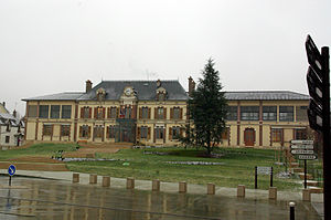
 Monéteau town hall |
||
Monéteau is a French municipality with 3985 inhabitants (as of January 1 2017) in the department of Yonne in the region Bourgogne Franche-Comté ; it belongs to the arrondissement of Auxerre . The municipality is partly part of the canton Auxerre-2 . The inhabitants are called Monestésien (ne) s .
geography
Monéteau is located on the Yonne River . Monéteau is surrounded by the neighboring municipalities of Gurgy in the north, Héry in the northeast, Villeneuve-Saint-Saulves in the east, Auxerre in the south, Perrigny in the west and Appoigny in the northwest.
The A6 autoroute runs through the municipality . The Route nationale 6 limits the west side, the Route nationale 77 in the southeast. The Monéteau-Gurgy station is served by TER Bourgogne trains.
history
The fact that the municipality belongs to two different cantons can be explained by the merger with the former municipality of Sougère-sur-Sinotte in 1972.
Population development
| year | 1962 | 1968 | 1975 | 1982 | 1990 | 1999 | 2006 | 2011 |
| Residents | 1,364 | 1,734 | 2,869 | 3,821 | 4,239 | 4,226 | 3,898 | 3,909 |
Attractions
- Archaeological dig site Sur Macherin
- Saint-Cyr church
- Eiffel Bridge
- Colbert Castle
- Route national 6 stone bridge
- Villa Montmorency
- Lock and weir of the Yonne
Community partnerships
There is a partnership with the German municipality of Föhren in Rhineland-Palatinate .

