
Deux Rivières
| Deux Rivières | ||
|---|---|---|
|
||
| region | Bourgogne-Franche-Comté | |
| Department | Yonne | |
| Arrondissement | Auxerre | |
| Canton | Joux-la-Ville | |
| Community association | Chablis Villages et Terroirs | |
| Coordinates | 47 ° 41 ′ N , 3 ° 42 ′ E | |
| height | 106-289 m | |
| surface | 31.81 km 2 | |
| Residents | 1,260 (January 1, 2017) | |
| Population density | 40 inhabitants / km 2 | |
| Post Code | 89460 | |
| INSEE code | 89130 | |

Deux Rivieres is a French commune with 1,260 inhabitants (as of January 1 2017) in the department of Yonne in the region Bourgogne Franche-Comté ; it belongs to the arrondissement of Auxerre . The municipality belongs to the canton of Joux-la-Ville .
geography
Deux Rivières is located about 18 kilometers south-southeast of Auxerre on the Yonne and the Cure . Deux Rivières is surrounded by the neighboring communities of Irancy in the north, Saint-Cyr-les-Colons in the north and northeast, Vermenton in the east, Bessy-sur-Cure in the south, Prégilbert in the south and southwest, Sainte-Pallaye in the southwest, Bazarnes in the west and southwest and Vincelles to the west and northwest.
structure
| District | former INSEE code |
Area (km²) | Population (2017) |
|---|---|---|---|
| Cravant | 89130 | 22.54 | 814 |
| Accolay | 89001 | 9.27 | 446 |
Attractions
- Saint-Pierre-et-Saint-Paul church in Cravant, Monument historique
- 11th century Saint-Nizier church
- Beffroi from Cravant
- Donjon of Cravant
- casemate
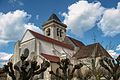
Saint-Pierre-et-Saint-Paul church

Saint-Nizier church

Beffroi
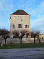
Donjon of Cravant
.jpg)


Personalities
- Léon Breton (1861–1940), cycling official