
Tannerre-en-Puisaye
| Tannerre-en-Puisaye | ||
|---|---|---|
|
||
| region | Bourgogne-Franche-Comté | |
| Department | Yonne | |
| Arrondissement | Auxerre | |
| Canton | Coeur de Puisaye | |
| Community association | Puisaye-Forterre | |
| Coordinates | 47 ° 44 ' N , 3 ° 8' E | |
| height | 168-242 m | |
| surface | 28.93 km 2 | |
| Residents | 283 (January 1, 2017) | |
| Population density | 10 inhabitants / km 2 | |
| Post Code | 89350 | |
| INSEE code | 89408 | |
 Town hall (Mairie) of Tannerre-en-Puisaye |
||

Tannerre-en-Puisaye is a French municipality with 283 inhabitants (as of January 1 2017) in the Yonne department in the region of Bourgogne Franche-Comté ; it belongs to the arrondissement of Auxerre and the canton of Cœur de Puisaye (until 2015: canton of Bléneau ). The inhabitants are called Tannerrois .
geography
Tannerre-en-Puisaye is located about 33 kilometers west-southwest of Auxerre on the Branlin River . Tannerre-en-Puisaye is surrounded by the neighboring communities of Champignelles in the north and north-west, Villiers-Saint-Benoît in the north-east, Dracy in the east, Mézilles in the south and east, Saint-Fargeau in the south-west and Villeneuve-les-Genêts in the west.
Population development
| year | 1962 | 1968 | 1975 | 1982 | 1990 | 1999 | 2006 | 2013 |
| Residents | 421 | 373 | 335 | 286 | 256 | 309 | 318 | 294 |
| Source: Cassini and INSEE | ||||||||
Attractions
- Saint Martin Church
- lock
- historical town center
- Mill and forge
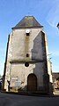
Saint Martin Church

Mill and forge


Web links
Commons : Tannerre-en-Puisaye - Collection of images, videos and audio files