
Charbuy
| Charbuy | ||
|---|---|---|

|
|
|
| region | Bourgogne-Franche-Comté | |
| Department | Yonne | |
| Arrondissement | Auxerre | |
| Canton | Auxerre-2 | |
| Community association | Auxerrois | |
| Coordinates | 47 ° 49 ′ N , 3 ° 28 ′ E | |
| height | 115-212 m | |
| surface | 23.4 km 2 | |
| Residents | 1,865 (January 1, 2017) | |
| Population density | 80 inhabitants / km 2 | |
| Post Code | 89113 | |
| INSEE code | 89083 | |
| Website | http://www.charbuy.fr/ | |
 Charbuy Town Hall |
||

Charbuy is a French commune with 1,865 inhabitants (as of January 1 2017) in the department of Yonne in the region Bourgogne Franche-Comté ; it belongs to the arrondissement of Auxerre . The municipality belongs to the canton Auxerre-2 (until 2015: canton Auxerre-Nord ). The inhabitants are called Charbuysien (ne) s .
geography
Charbuy is about eight kilometers west-northwest of Auxerre . Charbuy is surrounded by the neighboring communities of Fleury-la-Vallée in the north, Branches in the northeast, Perrigny in the east, Saint-Georges-sur-Baulche in the southeast, Villefargeau in the south, Lindry in the southwest and Poilly-sur-Tholon in the west and northwest.
Population development
| year | 1962 | 1968 | 1975 | 1982 | 1990 | 1999 | 2006 | 2012 |
| Residents | 778 | 744 | 838 | 1,171 | 1,463 | 1,607 | 1,596 | 1,780 |
| Source: Cassini and INSEE | ||||||||
Attractions
- Saint-Médard church from the 15th century
- Charbuy Castle

Saint-Médard church
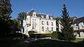
Charbuy Castle
.jpg)

Community partnerships
There is a partnership with the German municipality of Serrig in Rhineland-Palatinate .