Sementron
| Sementron | ||
|---|---|---|
|
|
||
| region | Bourgogne-Franche-Comté | |
| Department | Yonne | |
| Arrondissement | Auxerre | |
| Canton | Vincelles | |
| Community association | Puisaye-Forterre | |
| Coordinates | 47 ° 39 ′ N , 3 ° 21 ′ E | |
| height | 214–339 m | |
| surface | 11.7 km 2 | |
| Residents | 110 (January 1, 2017) | |
| Population density | 9 inhabitants / km 2 | |
| Post Code | 89560 | |
| INSEE code | 89383 | |
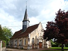
 Town hall (Mairie) of Sementron |
||
Sementron is a French municipality with 110 inhabitants (as of January 1 2017) in the department of Yonne in the region Bourgogne Franche-Comté (2015: Burgundy ). The municipality belongs to the arrondissement of Auxerre and the canton of Vincelles (until 2015 canton of Courson-les-Carrières ).
geography
Sementron is located in the south of the Puisaye countryside , about 24 kilometers southwest of Auxerre . Sementron is surrounded by the neighboring communities of Levis in the north and northwest, Ouanne in the east and northeast, Taingy in the east and southeast, Sougères-en-Puisaye in the south and Lain in the west and southwest.
Population development
| year | 1962 | 1968 | 1975 | 1982 | 1990 | 1999 | 2006 | 2013 |
| Residents | 170 | 158 | 117 | 107 | 93 | 99 | 115 | 116 |
| Source: Cassini and INSEE | ||||||||
Attractions
- Church of Sainte-Geneviève-et-Saint-Pierre, Monument historique
- Castle Test-Milon
Web links
Commons : Sementron - collection of images, videos and audio files

