Daule
| Daule | ||
|---|---|---|
|
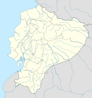
Coordinates: 1 ° 52 ′ S , 79 ° 59 ′ W Daule on the map of Ecuador
|
||
| Basic data | ||
| Country | Ecuador | |
| province | Guayas | |
| Canton | Daule | |
| City foundation | 1537 | |
| Residents | 87,508 (2010) | |
| - in the metropolitan area | 120,326 | |
| City insignia | ||
| Detailed data | ||
| surface | 187 km 2 | |
| Population density | 468 inhabitants / km 2 | |
| height | 7 m | |
| City structure | 7 parroquias urbanas | |
| Waters | Río Daule | |
| prefix | (+593) 4 | |
| Time zone | UTC -5 | |
| City Presidency | Pedro Salazar Barzola | |
| Website | ||
The city of Daule , also called Santa Clara de Daule , is located on the river of the same name in the Guayas province in Ecuador . Daule is the seat of the canton of the same name . The city with 34,632 inhabitants (2005) is 44 km north of the provincial capital Guayaquil .
Canton of Daule
The canton of Daule was established in 1820 as the canton of the Free Province of Guayaquil under José Joaquín de Olmedo before it joined Greater Colombia and is older than the Republic of Ecuador, which was founded in 1830 from the disintegrating Greater Colombia. It has around 84,500 inhabitants (2005) and was one of the largest cantons in the country in the 19th century.
In the 20th century, a number of new cantons were spun off from its area; around a third of the 28 cantons in the province of Guayas today are outsourced from Daule or its “daughter cantons”.
The canton still covers an area of 2747 km², which borders the cantons of Santa Lucía (in the north), Lomas de Sargentillo (in the west), Guayaquil (in the south) and Salitre and Samborondón (in the east). Daule is generally known as the rice chamber of Ecuador , as rice is mainly grown in the canton. In addition to cocoa , corn and tropical fruits (especially noticeable are mango plantations by) grown. The industry is primarily rice processing (peeling, rice mills).


