
Dijleland


Dijleland is the name of a region in Flanders that extends through the center of the province of Flemish Brabant in a south-north direction between Brussels and Leuven . The area of the region includes 14 communities. The name of the area comes from the river Dijle , whose valley, which runs from south to north, runs through the region for the most part on the eastern edge. In the east, the Dijleland is actually limited by the urban area of Leuven and the Hageland , which fill the entire rest of the eastern part of the province of Flemish Brabant . In the north, the Dijleland goes into the Brabant Kempenover. In the southeast, from Löwen in the direction of Oud-Heverlee, the extensive wooded areas of Meerdaalwoud, Heverleebos and Egenhovenbos (once part of the coal forest ) form a natural boundary.


The Dijleland (left) and the Hageland (right) in the province of Flemish Brabant.
The names of the 14 municipalities in Dijleland are (from north to south):
- Boortmeerbeek , Kampenhout ,
- Keerbergen , Haacht , Herent ,
- Steenokkerzeel , Kortenberg ,
- Zaventem ,
- Bertem , Oud-Heverlee ,
- Tervuren , Huldenberg ,
- Overijse , Hoeilaart
The latter four municipalities are located in the southern section of the Dijleland and form the Druivenstreek . Dijleland itself forms the eastern part of the rural green belt ( Groene Gordel ) that surrounds the capital Brussels.
Pictures from the Dijleland
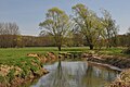
The Dijle in Neerijse, Gem. Huldenberg.

The valley of the Dijle in the nature reserve in Neerijse.

The Nieuwe Hansbrug , bridging the Dijle at Keerbergen and Haacht.

The Voer in Leefdaal, Gem. Bertem

The Voer in Leefdaal, Gem. Bertem

The Voer in Vossem near Tervuren
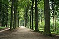
Alley of beeches in the arboretum of Tervuren

Robianokasteel and Hof Over 't Water in Tervuren

The Kasteelvijver (castle pond ) in Tervuren

The Meerdaal-Woud near Lions

The Minnebron in Heverleebusch, Gem. Oud-Heverlee

The Ekstermolen , an old windmill in Oud-Heverlee


Well-known people
Ludwig van Beethoven's ancestors come from Kampenhout and Boortmeerbeek in the north of Dijleland.
Web links
Coordinates: 50 ° 53 ' N , 4 ° 35' E