
Dissé-sous-le-Lude
| Dissé-sous-le-Lude | ||
|---|---|---|
|
||
| local community | Le Lude | |
| region | Pays de la Loire | |
| Department | Sarthe | |
| Arrondissement | La Flèche | |
| Coordinates | 47 ° 36 ' N , 0 ° 9' E | |
| Post Code | 72800 | |
| Former INSEE code | 72117 | |
| Incorporation | 1st January 2018 | |
| status | Commune déléguée | |

Dissé-sous-le-Lude is a commune Déléguée in the French commune of Le Lude with 544 inhabitants (as of January 1 2017) in the department of Sarthe in the region Pays de la Loire . The inhabitants are called disséens .
On January 1, 2018, the municipality of Dissé-sous-le- Lude was incorporated into Le Lude . It belonged to the arrondissement of La Flèche and the canton of Le Lude .
geography
Dissé-sous-le-Lude is about 39 kilometers south of Le Mans on the Marconne River . Dissé-sous-le-Lude is surrounded by the villages of Le Lude in the north and north-east, Broc in the east and south-east, Chigné in the south and south-west and Savigné-sous-le-Lude in the west.
Population development
| year | 1962 | 1968 | 1975 | 1982 | 1990 | 1999 | 2006 | 2013 |
| Residents | 627 | 594 | 591 | 649 | 594 | 556 | 554 | 564 |
| Source: Cassini and INSEE | ||||||||
Attractions
- Menhir from Lorrière
- Saint-Martin-de-Vertou church from the 11th century, alterations from the 15th century, burned down and rebuilt in 1869
- Lorrière Castle from the 15th century, considerably redesigned between 1865 and 1875
- La Cour-de-Broc castle from the 17th century
- Le Mortier Castle, alterations from the 16th, 17th and 19th centuries
- Sainte-Marie priory (also: Le Raillon monastery) with a chapel from the 11th / 12th. Century, conversions from the 15th century
- Manor house of La Giraudière from the 16th / 17th centuries century
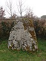
Menhir from Lorrière

Saint-Martin-de-Vertou church

Chapel of the Sainte-Marie priory
.JPG)


literature
- Le Patrimoine des Communes de la Sarthe. Flohic Editions, Volume 1, Paris 2000, ISBN 2-84234-106-6 , pp. 730-731.