
Chigné
| Chigné | ||
|---|---|---|
|
||
| local community | Noyant Villages | |
| region | Pays de la Loire | |
| Department | Maine-et-Loire | |
| Arrondissement | Saumur | |
| Coordinates | 47 ° 35 ' N , 0 ° 5' E | |
| Post Code | 49490 | |
| Former INSEE code | 49098 | |
| Incorporation | 15th December 2016 | |
| status | Commune déléguée | |

Chigné is a town and commune Déléguée in the French commune of Noyant-Villages with 309 inhabitants (at January 1, 2017) in the department of Maine-et-Loire in the region of Pays de la Loire . The inhabitants are called Chignois .
Chigné became on December 15, 2016 with 13 other municipalities, namely Auverse , Breil , Broc , Chalonnes-sous-le-Lude , Chavaignes , Dénezé-sous-le-Lude , Genneteil , Lasse , Linières-Bouton , Meigné-le-Vicomte , Méon , Noyant and Parçay-les-Pins merged to form the new municipality of Noyant-Villages.
geography
Chigné is located about 47 kilometers east-northeast of Angers in the Baugeois landscape . The area is affected by the Marconne River .
Population development
| year | 1962 | 1968 | 1975 | 1982 | 1990 | 1999 | 2006 | 2013 |
|---|---|---|---|---|---|---|---|---|
| Residents | 489 | 448 | 363 | 296 | 302 | 271 | 297 | 308 |
| Source: Cassini and INSEE | ||||||||
Attractions

- L'Aurière dolmen and menhir, monument historique since 1983
- Saint-Pierre-Saint-Paul church from the 11th / 12th centuries century
- Remains of a tower hill castle (moth) from the 11th / 12th centuries. century
- 15th century mansion of Le Bien
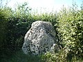
Menhir from L'Aurière

Saint-Pierre-Saint-Paul Church

_%C3%89glise_Saint-Pierre_et_Saint-Paul_03.jpg)
literature
- Le Patrimoine des Communes de Maine-et-Loire . Flohic Editions, Volume 2, Paris 2001, ISBN 2-84234-117-1 , pp. 912-915.
Web links
Commons : Chigné - collection of images, videos and audio files