
Dnister Liman
| Dnister Liman | ||
|---|---|---|

|
||
| Satellite image of the Dniester Liman | ||
| Geographical location |
|
|
| Tributaries | Dniester | |
| Places on the shore | Bilhorod-Dnistrovskyj , Owidiopol , Satoka | |
| Data | ||
| Coordinates | 46 ° 14 ' N , 30 ° 22' E | |
|
||
| Altitude above sea level | 0 m | |
| surface | 360 km² | |
| length | 42.5 km | |
| width | 12 km | |
| volume | 0.387.4 km³ | |
| Maximum depth | 2.7 m | |
| Middle deep | 1.8 m | |
|
particularities |
||

The Dniester Liman ( Ukrainian Дністровський лиман / Dnistrowskyj Lyman ) is an estuary of the Dniester River in the Black Sea . The northern part of Dnistr estuary is a protected Ramsar - wetland .
geography

Akkerman fortress on the Dniester Liman
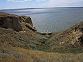
The Liman is located in the Odessa region between the Rajon Owidiopol and the Rajon Bilhorod-Dnistrovskyj on the northwestern shore of the Black Sea.
The mouth is separated from the Black Sea by a wide (40 to 500 meters) sandbank (Buhas) and connected to it only by a narrow arm of water.
Flora and fauna
Flora
Wildlife
fishes
- Bream (Abramis brama)
- Common carp (Cyprinus carpio)
- Zander (Sander lucioperca)
- Perch (Perca fluviatilis)
- Northern pike (Esox lucius)
Birds
- Sandpiper (Limnodromus)
- Mallard Duck (Anas platyrhynchos)
- Mute Swan (Cygnus olor)
Web links
Commons : Dnister-Liman - collection of images, videos and audio files
The village of Roksolany is the ancient city of Nikonion
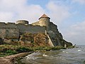
Akkerman Fortress in Bilhorod-Dnistrovskyi
Silting up in the mouth area


