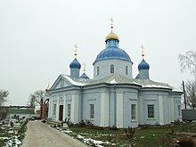
Owidiopol
| Owidiopol | ||
| Овідіополь | ||

|
|
|
| Basic data | ||
|---|---|---|
| Oblast : | Odessa Oblast | |
| Rajon : | Owidiopol Raion | |
| Height : | 2 m | |
| Area : | 12.52 km² | |
| Residents : | 11,818 (2004) | |
| Population density : | 944 inhabitants per km² | |
| Postcodes : | 67800 | |
| Area code : | +380 4851 | |
| Geographic location : | 46 ° 15 ' N , 30 ° 26' E | |
| KOATUU : | 5123755100 | |
| Administrative structure : | 1 urban-type settlement | |
| Mayor : | Valentyna Homenyuk | |
| Address: | вул. Суворова 2 67801 смт. Овідіополь |
|
| Website : | http://www.ovidiopol.info/ | |
| Statistical information | ||
|
|
||
Owidiopol (Ukrainian Овідіополь ; Russian Овидиополь , Romanian Ovidiopol , Turkish Hacıdere ) is an urban-type settlement in southern Ukraine , about 32 kilometers west of Odessa on the east bank of the Dniester Liman . It is the center of the Owidiopol Rajon of the same name .
The settlement was built at the end of the 18th century as a fortress to protect the mouth of the Dnister and the Black Sea from attacks by the Turks. On June 15, 1793, the foundation stone for construction was laid on the ruins of an older Turkish fortification (destroyed in 1769). In 1795, by decree of Tsarina Katharina , the name was given as Owidiopol in honor of the poet Ovid, who was in exile in the area . In 1970 the place was granted urban-type settlement status.
Since 1916 there has also been a train station in the village as the end of the line from Odessa, but the importance of the train station has decreased significantly due to the extension of the line to Bilhorod-Dnistrovskyj .


