Dobranovský potok
|
Dobranovský potok Rodowitzer Bach, Dobernbach |
||
|
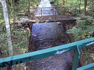
Bridge of the Vlčí Důl cycle path across Dobranovský potok near Dobranov |
||
| Data | ||
| Water code | CZ : 1-14-03-051 | |
| location | Czech Republic | |
| River system | Elbe | |
| Drain over | Ploučnice → Elbe → North Sea | |
| source | west of Cvikov in the Zákupská pahorkatina 50 ° 46 '51 " N , 14 ° 36' 28" O |
|
| Source height | 375 m nm | |
| muzzle | south of Dobranov in the Ploučnice coordinates: 50 ° 40 ′ 33 ″ N , 14 ° 35 ′ 39 ″ E 50 ° 40 ′ 33 ″ N , 14 ° 35 ′ 39 ″ E |
|
| Mouth height | 251 m nm | |
| Height difference | 124 m | |
| Bottom slope | 7.2 ‰ | |
| length | 17.2 km | |
| Catchment area | 52.9 km² | |
| Drain |
MQ |
410 l / s |
The Dobranovský potok (German Rodowitzer Bach , also Dobernbach ) is a right tributary of the Ploučnice in the Czech Republic .
course
The Dobranovský potok rises west of Cvikov or southeast of Svor in the Zákupská pahorkatina ( Reichstadt hill country ) belonging to the Ralská pahorkatina ( Rollberg hill country ). Its source is at the northern foot of the Hrouda ( Balleberg , 452 m). On its upper course, initially to the southwest, then to the south, the Dobranovský potok forms a wooded valley with sandstone cliffs over a length of two kilometers, which is known as Údolí samoty ( Luzengrund ). At the Hunter House in Radvanec of from Údolí vzdechů (opens sigh reason coming) Klíčský Potok ( Kleis Bach ) to.
The middle course of the stream flows through Radvanec and Sloup v Čechách , between the two places it is dammed in the Radvanecký rybník pond. At the north-western foot of the Slavíček ( Slabitschken , 535 m) the Dobranovský potok reaches the Bürgstein-Schwoikaer Schweiz ; its course leads west past the rock castle Sloup . The Cikánský důl ( Gypsy Ground ) canyon branches off to the left at Janov . There the brook turns south again and reaches Chomouty and Pihel, it flows around Pihelský vrch ( Pihlerberg , 315 m) with the remains of Pihel Castle.
The lower reaches of the Dobranovský potok runs in a south-easterly direction through Dolní Pihel, Bukovany, Malý Bor, Písečná and Dobranov. After 17.2 kilometers, the Dobranovský potok joins the Ploučnice south of Dobranov .
Shortly before its mouth, the stream is bridged by the Vlčí Důl cycle route, which was laid out on a disused section of the Řetenice – Liberec railway line .
The stream is a trout water, about half of its course fishing is prohibited.
Tributaries
- Klíčský potok (r), in Radvanec
- Chotovický potok (r), near Janov
- Pihelský potok (r), in Pihel
- Šidlovský potok (l), above Dobranov
Ponds
- Radvanecký rybník, between Radvanec and Sloup v Čechách
- Hradní rybník, by the Sloup rock castle
- Pivovarský rybník, in Pihel
Web links
- data sheet
- Description of the Luzengrund on luzicke-hory.cz
- Description of the gypsy ground on luzicke-hory.cz


