Dolina (Grafenstein municipality)
|
Dolina ( village ) locality |
||
|---|---|---|
|
|
||
| Basic data | ||
| Pole. District , state | Klagenfurt-Land (KL), Carinthia | |
| Judicial district | Klagenfurt | |
| Pole. local community | Grafenstein ( KG Replach) | |
| Coordinates | 46 ° 38 '27 " N , 14 ° 27' 3" E | |
| Residents of the village | 128 (January 1, 2020) | |
| Building status | 43 (2001) | |
| Statistical identification | ||
| Locality code | 00699 | |
| Counting district / district | Grafenstein area (20409 001) | |
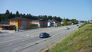
 The Packer Straße (B70) in Dolina |
||
| Source: STAT : index of places ; BEV : GEONAM ; KAGIS | ||
Dolina ( Slovenian : Dolina , the valley) is a place in the Grafenstein municipality in Carinthia. The village is a street village south of Poggersdorf and has 99 inhabitants (as of 2001 census).
Culture and sights
- Motorway Church Dolina , a branch church of the Poggersdorf parish, was once a popular and important Slovenian, now bilingual pilgrimage church, which is also of importance for the regional Slovenian cultural history as a whole.
literature
- Dehio manual. The art monuments of Austria: Carinthia. Dolina. Bundesdenkmalamt (Ed.), Verlag Anton Schroll & Co, third, expanded and improved edition, Vienna 2001, ISBN 3-7031-0712-X , p. 83.
- Stefan Singer: Cultural and Church History of the Deanery Tainach. Klagenfurt / Celovec [ea] 1995.

