Dolina Kasprowa
| Dolina Kasprowa | ||
|---|---|---|
|
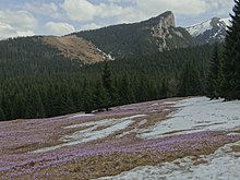
View from the hiking trail to the Kasprowy Wierch |
||
| location | Lesser Poland Voivodeship , Poland | |
| Waters | Kasprowy Potok | |
| Mountains | Western Tatras , Tatra , Carpathians | |
| Geographical location | 49 ° 15 '2 " N , 19 ° 58' 51" E | |
|
|
||
| height | 1110 to 1987 m npm | |
| climate | High mountain climate | |

The glacial formed by glacial Dolina Kasprowa is a valley in the Polish West Tatra in the Lesser Poland . It is located in the municipality of Zakopane in the powiat Tatrzański .
geography
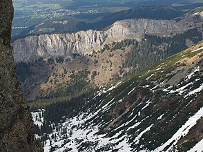
The valley is a south-eastern side valley of the main valley Dolina Bystrej and is surrounded by mountains up to 1987 meters high. a. the Kasprowy Wierch . The rock walls in the valley are made of limestone with numerous caves, of which the three-kilometer long Jaskinia Kasprowa Niżnia is the most famous.
The valley falls from south to north from about 1987 meters in altitude to 1110 meters in altitude. It is traversed by the mountain river Kasprowy Potok , which is formed by the confluence of the mountain streams Stare Szałasiska and Zielone Koryciska at an altitude of 1382 meters. Much of the valley's waters flow underground. The karst spring Kasprowe Wywierzysko and the mountain lake Kasprowy Stawek are located in the valley at an altitude of 1290 meters.
The valley has two side valleys:
etymology
The name can be translated as "Valley of the Kasper". The name comes from the Hala Kasprowa alpine pasture .
Flora and fauna
The valley lies above and below the tree line and is covered with mountain pines in the upper area and coniferous forest in the lower area. The valley is a retreat for numerous mammals and bird species.
climate
There is a high mountain climate in the valley.
Alpine farming
Before the Tatra National Park was established in 1954, the valley was used for alpine farming. After that, the owners of the alpine pastures were expropriated or forced to sell. The largest alpine pasture in the valley was the Hala Kasprowa , which was later divided into an upper and a lower part. Iron ore was also mined in the valley. The former shafts are still there.
tourism
A hiking trail from Zakopane leads through the valley.
- ▬ A green marked hiking trail from the Kuźnice district of Zakopaneto the Myślenickie Turnie and on to the Kasprowy Wierch .
literature
- Zofia Radwańska-Paryska, Witold Henryk Paryski, Wielka encyklopedia tatrzańska , Poronin, Wyd. Górskie, 2004, ISBN 83-7104-009-1 .
- Tatry Wysokie słowackie i polskie. Mapa turystyczna 1: 25.000, Warszawa, 2005/06, Polkart ISBN 83-87873-26-8 .


