Donebach
|
Donebach
municipality Mudau
|
|
|---|---|
| Coordinates: 49 ° 33 ′ 39 ″ N , 9 ° 11 ′ 32 ″ E | |
| Height : | 463 m |
| Residents : | 370 |
| Incorporation : | March 1, 1974 |
| Postal code : | 69427 |
| Area code : | 06284 |
Donebach is a district of Mudau in the Odenwald with around 370 inhabitants.
geography
Donebach is located in northern Baden-Württemberg , in the Baden Odenwald, not far from the state border with Bavaria . The map shows Donebach as a street location. To the west of Donebach is the town of Mörschenhardt (approx. 2 km away), to the east is Ünglert (approx. 1.5 km away) and to the southeast is Mudau (approx. 3 km away).
history
Donebach was created in the 11th century as a clearing settlement of the Amorbach monastery in the valley basin of the Donebach stream of the same name (done means to rush). In 1462 the place was called " Thonbach ". From 1585 to 1925 the place was called Dumbach , but was then renamed to the first Donebach , recorded in documents in 1271 .
In 1495 about 80 people lived in Donebach. Around 1750 there were 145 inhabitants and there is said to have been an inn called "Zum Ross". Farmers in Donebach also took part in the agricultural revolution in 1848. 18 years later (1866) the schoolhouse was built and the parish church in 1927. The French campaign of the Hitler dictatorship also had consequences for Donebach. In the years 1939 and 1940 the Wehrmacht cleared around 2/3 of the communal forest that could be cut to make a makeshift airfield, thereby robbing the town of a good source of income. The airfield was never completed due to the quick victory over France.
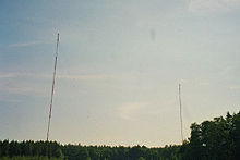
In 1950 the population rose briefly to 584 residents due to the influx of evacuees and displaced persons . In 1965, the Deutsche Bundespost erected 4 transmitter masts on the airfield for broadcasting Deutschlandfunk, which in 1982 were reduced to two towers, albeit with a height of 363 meters. The two towers were blown up on March 2, 2018.
As part of the community reform, Donebach joined the community of Mudau on March 1, 1974. Donebach was incorporated into Mudau as early as 1935, but was separated again in 1945.
The inn "Linde" closed its doors in 1976, since then the center of village life has been the restaurant of FC Donebach and since the 1980s also the common room of the youth center Donebach, which was built in the rooms of the former milk delivery point.
A modern infrastructure was created in Donebach with the renovation of the water supply, the construction of the sewage system and the village-oriented expansion of the through-town in the 1990s.
Today there are 13 streets in Donebach (Am Sportplatz, Ampfad, Amselweg, Drosselgasse, Fasanenweg, Häuseräckerstraße, Odenwaldstraße, Prof. Eiermannstraße, Reiterstraße, Schöne Aussicht, Senderstraße, Ünglertstraße, Wildenburgweg). In 2000 the “Neuhof” building area was opened up against the backdrop of the transmission masts.
Today Donebach has about 370 inhabitants.
politics
coat of arms
The coat of arms shows in red a lowered silver wavy bar above which there is a six-spoke silver wheel ( Mainz wheel , reminiscent of belonging to Kurmainz ).
mayor
As a district of Mudau, Donebach does not have its own mayor. The mayor of Mudau, and thus also of the Donebach district, has been Dr. Norbert Rippberger, who grew up in Donebach and spent his youth there.
Attractions
On a clear plateau immediately west of the local situation was 1967 to 2018 of the transmitter Donebach , the two 363-meter high steel lattice towers on the long-wave Germany radio radiated. The widely visible masts were the second tallest structures in Germany.
The broadcasting operation was stopped at the end of 2014 for cost reasons, the masts were felled on March 2, 2018.
Business
In Donebach there are six dairy farms and even more farms with pig farming. There is also a locksmith's shop, a bricklayer's business, a bakery sales point, an electrician, a bank branch and an agricultural machinery dealer.
Web links
Individual evidence
- ^ Federal Statistical Office (ed.): Historical municipality directory for the Federal Republic of Germany. Name, border and key number changes in municipalities, counties and administrative districts from May 27, 1970 to December 31, 1982 . W. Kohlhammer, Stuttgart / Mainz 1983, ISBN 3-17-003263-1 , p. 485 .
- ↑ Discover regional studies online, Donebach. LEO-BW, accessed December 20, 2014 .


