Donousa
|
Donousa municipality Δημοτική Ενότητα Δονούσης (Δονούσα) |
||
|---|---|---|
|
|
||
| Basic data | ||
| State : |
|
|
| Region : |
South Aegean
|
|
| Regional District : | Naxos | |
| Municipality : | Naxos and Lesser Cyclades | |
| Geographic coordinates : | 37 ° 7 ' N , 25 ° 49' E | |
| Height above d. M .: | 386 m Vardia |
|
| Area : | 13.750 km² | |
| Residents : | 167 (2011) | |
| Population density : | 12.1 inhabitants / km² | |
| Code No .: | 670202 | |
| Structure: |
1 municipality |
|
| Located in the municipality of Naxos and Lesser Cyclades and in the regional unit of Naxos | ||
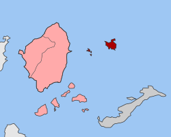
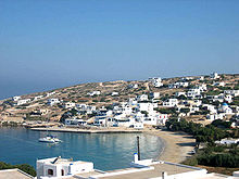
The Greek island Donousa ( Greek Δονούσα [ ðɔnusa ] ( f. Sg. )) Is within the Cyclades to the group of Cyclades little . Since 2011, it has formed a district of the municipality of Naxos and the Little Cyclades in the South Aegean region with some other, uninhabited small islands .
location
Donousa is the northeasternmost island of the Small Cyclades and is located about 16 km east of Naxos . Amorgos is 23 km southeast and Pano Koufonisi 23 km southwest. The coastline of 13,652 km². large island, with a maximum size of 6 × 6 km, is strongly divided by elongated capes and small bays. In the immediate vicinity of the island are other small rocky islets, of which Skylonisi on the northeast coast is the largest. Two small archipelagos belong to the municipality of Donousa, the islands of the Makares group (Μάκαρες) are 8 km to the southwest. The three rock islands of the Melandii group (Μελάντιοι) are about 13.5 km northeast.
Donousa is hilly to the north and increasingly mountainous to the east. The highest peaks Papas (Πάπας, 383 m) and Vardia (Βάρδια, 386 m) are in the northeast and east. The bushy vegetation forms of the Phrygana characterize the landscape of the island to a large extent.
history
On Donousa already in the 3rd millennium BC. At Achtia ton Agrilion (Αχτιά των Αγριλιών) and Myti tou Trachyla (Μύτη του Τραχύλα) two settlements of the prehistoric Cycladic culture were established, which were specialized in fishing and cattle breeding.
During the Geometric Period from the 10th to the 7th century BC Donousa experienced a heyday, as can be deduced from finds from the fortified settlement Vathy Limenari (Βαθύ Λιμενάρι) in the south of the island, with a pronounced influence from the Dodecanese islands . Numerous cremation sites were uncovered around the settlement.
The island was probably a place of exile during Roman times.
In the Middle Ages and under Ottoman rule, Donousa was a haven for pirates.
In the 18th and 19th centuries, the island was called Denousa (Ντενούσα or Δενούσα), Stenoza (Στενόζα) or Spinosa (Σπινόζα). Around 1830 shepherds from Egiali settled on Amorgos as tenants to cultivate the land.
From the beginning of the 20th century until 1938, iron, aluminum and copper were mined at Kedros. About 3,000 people lived on the island at that time. During the Second World War , Italy first occupied Donousa from 1941 to 1943 and then until 1944 by the German Wehrmacht .
structure
Today's Donousa district has 167 inhabitants
- Donousa (Δονούσα ( f. Sg. )) Also Stavros (Σταυρός ( m. Sg. )) Or Kambos (Κάμπος ( m. Sg. )), 141
- Kalotaritissa (Καλοταρίτισσα ( f. Sg. )), 2
- Mersini (Μερσίνη ( f. Sg. )), 22
- Charavgi (Χαραυγή ( f. Sg. )) Or Mesaria (Μεσαριά ( f. Sg. )), 2
- as well as the uninhabited islands
economy
Up until the 1950s, mainly tobacco and onions were grown. However, the worsening economic situation since the 1960s and the associated emigration resulted in agricultural crops becoming deserted.
Only with the gradual improvement of shipping connections and the slow growth of tourism did the economic situation improve.
Today the residents earn their income mainly from tourism. Agriculture and fishing are only practiced to a small extent and mainly to cover their own needs.
traffic
Donousa is called regularly (two to four times a week) by ferries from Piraeus and several times a week by the "Express Scopelitis", which connects Donousa with Amorgos, Naxos and the other Lesser Cyclades. There are further connections three times a week from Syros. During the high season, a bus leaves the port several times a day, which goes to different places and beaches as required.
natural reserve
Donousa is part of the Natura 2000 -region GR4220013 Mikres Kyklades: Irakleia, Schinoussa, Koufonisia, Keros, Antikeri kai Thalassia Zoni (Μικρές Κυκλάδες: από Κέρο μέχρι Ηράκλεια, Σχοινούσσα, Κουφονήσια, Κέρος, Αντικέρι και θαλάσσια ζώνη).
particularities
In contrast to the neighboring islands, there are no cicadas on the island . The cause has not yet been clarified.
Web links
Individual evidence
- ↑ a b Results of the 2011 census, Greek Statistical Office (ΕΛ.ΣΤΑΤ) ( Memento from June 27, 2015 in the Internet Archive ) (Excel document, 2.6 MB)
- ↑ Ελληνική Στατιστική Αρχή [ΕΛΣΤΑΤ] (Ed.): Στατιστική Επετηρίδα της Ελλάδος (Statistical Yearbook of Greece) 2009 & 2010 . Piraeus 2011, p. 47 .
- ↑ Donousa history, Aegean portal egeonet.gr ( page no longer available , search in web archives ) Info: The link was automatically marked as defective. Please check the link according to the instructions and then remove this notice. (Greek)
- ↑ Greek island of Donoussa: Kyklade looking cicada . Spiegel Online , May 15, 2015.


