Dowha (mountain)
|
Dowha Довга |
||
|---|---|---|
|
View of the ski area of Bukovel with the Dowha |
||
| height | 1371 m | |
| location |
Ivano-Frankivsk Oblast , Ukraine |
|
| Mountains | Carpathian Mountains , Gorgany | |
| Coordinates | 48 ° 22 '0 " N , 24 ° 22' 14" E | |
|
|
||
The Dowha ( Ukrainian Довга ; Russian Dowga , Polish Douha ) is a 1371 m high mountain in the Gorgany , a mountain range of the Forest Carpathians in Ukraine .
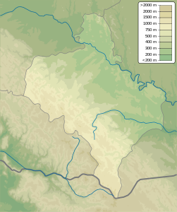
The mountain is located in the south of Nadvirna Rajon in the western Ukrainian Oblast Ivano-Frankivsk on the border with the Transcarpathian Oblast . The northern and southern slopes of the mountain are steep, the western slope is gentle. Depending on the source, the height of the Dowha is given as 1370.8 m to 1371.3 m .
In the northwest of the village is Dowha Bystrytsia River and is located in the southeast near the village Polyanytsya with the winter sports - Resort Bukovel of the largest and most modern ski resort Ukraine .
Individual evidence
- ↑ Institute for Natural Sciences, Geography and Natural History - The highest peaks of the Ukrainian Carpathians and their geomorphological regions , accessed on April 18, 2017 (Ukrainian)
- ↑ Description of Mount Dowha on kafa.ws , accessed on April 18, 2017 (Ukrainian)
- ↑ website for the village on karpaty.life ; accessed on April 18, 2017 (Ukrainian)

