
Downieville, California
| Downieville | |||
|---|---|---|---|
 Main Street in Downieville (2009) |
|||
| Location in California | |||
|
|||
| Basic data | |||
| State : | United States | ||
| State : | California | ||
| County : | Sierra County | ||
| Coordinates : | 39 ° 34 ′ N , 120 ° 50 ′ W | ||
| Time zone : | Pacific ( UTC − 8 / −7 ) | ||
| Residents : | 282 (as of 2010) | ||
| Population density : | 34.2 inhabitants per km 2 | ||
| Area : | 8.252 km 2 (approx. 3 mi 2 ) of which 8.238 km 2 (approx. 3 mi 2 ) is land |
||
| Height : | 904 m | ||
| Postal code : | 95936 | ||
| Area code : | +1 530 | ||
| FIPS : | 06-19794 | ||
| GNIS ID : | 2583000 | ||


Downieville is a census-designated place and the county seat in Sierra County in the US state of California . In 2010 the population was 282.
history
The place was founded in 1849 during the California gold rush . The settlement was first called because of its geographical location at the confluence of the Downie River and the North Fork in the northern Yuba "The Forks" (= confluence), but was then renamed after Major William Downie (1820-1893), the first mayor of Scotland the city. Downieville had a population of over 5,000 in 1851, but the number declined rapidly after 1865, after private gold prospecting practically came to a standstill. While many gold rush settlements in the northern hinterland of the city, such as Brand City, Whiskey Diggins, Poverty Hill or Poker Flat, were abandoned and fell into disrepair, Downieville was able to hold onto its favorable geographical location and its status as the seat of the government of Sierra County.
geography
Downieville is located at the confluence of the two small rivers North Yuba River and Downie River . The heavily forested mountains of the Sierra Nevada reach a height of over 2000 meters in the Downieville region.
Neighboring communities
| La Porte | Oxford Mill | Portola |
| Goodyears Bar |
.svg)
|
Loganville |
| Grass Valley , Nevada City | Alleghany | Kingvale , Soda Springs |
Infrastructure and transport links
- Downieville Community Hall
- Downieville Junior-Senior High School
- Sierra County Courthouse
- Western Sierra Medical Clinic
- Downieville is connected to the American road network via the CA 49 .
- The city has no rail connection.
- The nearest train stations are in Portola and Sacramento .
- The nearest international airports are in Reno and Sacramento .
Picture gallery
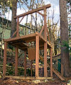
County sheriff's gallows; Galloway Road and Courthouse Square (2005)
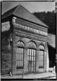
Wells Fargo Building (after 1933)
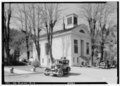
Courthouse (1934)

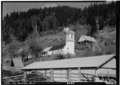
Church (1934)
Catholic Church (1934)

Hauptstrasse (1934)

Downieville (1934)

Personalities
Associated with Downieville
- Warren Harding (1924-2002), American mountaineer
- James Augustus Johnson (1829–1896), Lieutenant Governor of California
- Joseph C. McKibbin (1824-1896), American politician