Drogheda
| Drogheda Droichead Átha Drogheda |
||
|---|---|---|
|
|
||
| Coordinates | 53 ° 43 ′ N , 6 ° 21 ′ W | |
| Symbols | ||
|
||
|
Motto "Deus praesidium, mercatura decus" |
||
| Basic data | ||
| Country | Ireland | |
| Leinster | ||
| county | Louth | |
| ISO 3166-2 | IE-LH | |
| Residents | 30,435 | |
| Post Code | A92 | |
Drogheda (pronunciation: [ ˈdroheda ] or locally [ ˈdrɔːda ]; Irish : Droichead Átha , [ ˈdrɛçəd ˈɑː ] / [ ˈdrɛhəd ˈɑːhə ], "bridge over the ford") is a city in the Republic of Ireland with 30,435 inhabitants (as of 2011).
geography
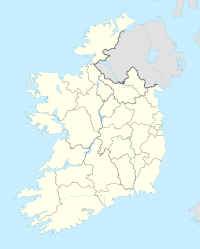
Drogheda is 45 kilometers north of Dublin in County Louth at the beginning of the mouth of the River Boyne and a few kilometers from the coast of the Irish Sea .
history
In 1649 the place was the scene of a bloody massacre by Oliver Cromwell's troops.
Attractions
In the immediate vicinity of Drogheda, especially in Brú na Bóinne, are some of the most important monuments in Ireland from pre-Christian times. They include the Hill of Tara and Newgrange . Newgrange special significance and fascination of researchers has achieved because every year a few days around the winter solstice just by a narrow gap above the entrance a ray of sunshine the entire interior of the tumulus enlightened.
The townscape is dominated by the Boyne Viaduct , which runs the Dublin - Belfast railway over the River Boyne.
Twin cities
- Bronte , Italy
- Saint-Mandé , France
Personalities
Sons and daughters of the town:
- Pierce Brosnan (born 1953), actor
- Anthony Byrne (1930-2013), boxer
- Tommy Byrne (* 1958), racing car driver
- Eamonn Campbell (1946-2017), folk musician, guitarist for the Dubliners
- Megan Campbell (* 1993), soccer player
- Ian Harte (born 1977), football player
- Gary Kelly (born 1974), soccer player
- Geraldine Byrne Nason (* 1959), Ambassador to France and to the United Nations
- Colin O'Donoghue (born 1981), actor
- Michael Scott (1905-1989), architect
- Steve Staunton (* 1969), football player and coach
Mayor:
- Michael Bell (1936–2011), Mayor 1984/85
Web links
- Website (English)
Individual evidence
- ↑ Sean's journey to our Paris 'twin'. In: Drogheda Independent. August 31, 2011, accessed September 21, 2012 .


