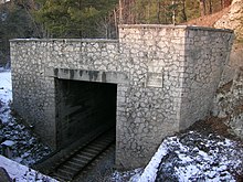
Eichstätt train station
|
Eichstätt train station
City of Eichstätt
Coordinates: 48 ° 52 ′ 12 ″ N , 11 ° 9 ′ 50 ″ E
|
||
|---|---|---|
| Height : | 426 m | |
| Residents : | 22 (1983) | |
| Postal code : | 85072 | |
| Area code : | 08421 | |
|
Location of Eichstätt train station in Bavaria |
||
|
Eichstätt-Bahnhof, Bahnhofstrasse 6 station building
|
||
Eichstätt-Bahnhof is a village in the Wasserzell district of the city of Eichstätt in the Upper Bavarian district of Eichstätt .
location
The place is on the Ingolstadt – Treuchtlingen railway line and should not be confused with the "Eichstätt-Stadt railway station" on the Eichstätt – Beilngries branch line, built in 1899, in the city itself .
history
The city of Eichstätt fought since 1858 to ensure that the new route from Ingolstadt is not led via Nassenfels to Dollnstein , but rather that Eichstätt is included. After the mayor of Eichstätt Georg Fehlner (1817-1891) had an audience with King Ludwig II in January 1866, the originally envisaged Schuttertal route was abandoned and the Adelschlag - Wasserzell route was decided Should lead near the episcopal city. With ministerial approval in January 1867, construction began that same year. This also made it necessary to erect service and residential buildings nearby. So from 1867 today's place "Eichstätt-Bahnhof" was created on the Treuchtlingen-Ingolstadt railway line that was opened in 1870. In 1882 there was a residential building, namely the station building itself, and five station guards' houses. In 1885 a narrow-gauge branch line was laid via Wasserzell and Rebdorf- Hofmühle to the city of Eichstätt, which was converted to standard gauge in 1934.
The district manual from 1906 lists the station and station 31 and 32; In 1937, Eichstätt station had 46 residents plus five residents of station 31 and two of station 32. The route to Eichstätt-Stadt has been running above Wasserzell since 1934 through the 189 m long so-called Schneckenberg tunnel under the western "Schneckenbuck".
Initially referred to as "Bahnhof (near Wasserzell)", then (as in 1875) as "Eichstätt, Bahnhof" or (as in 1900) as "Eichstätt Bahnstation", the settlement belonged to the municipality of Wasserzell in the Eichstätt district court . July 1972 incorporated into the large district town of Eichstätt.
In addition to the station buildings, there are now five residential buildings in Eichstätt-Bahnhof on both sides of the railway line and a stone gravel works at a Jura quarry; the branch line leading to the gravel works was shut down and dismantled towards the end of the 20th century. The district road EI 13 leads from Wasserzell through a tunnel under the railway line to the four properties south of the railway line.
Population development
- 1871: 24 (8 buildings)
- 1900: 54 (4 residential buildings)
- 1937: 53
- 1950: 90 (8 residential buildings)
- 1961: 52 (6 residential buildings)
- 1973: 40
- 1983: 22
literature
- Franz Xaver Buchner : The diocese of Eichstätt. Volume I, Eichstätt: Brönner & Däntler, 1937.
- Gerhard Hirschmann: Historical Atlas of Bavaria. Part of Franconia. Row I, Issue 6. Eichstätt. Beilngries - Eichstätt - Greding. Munich 1959.
- The Eichstätt area in past and present , 2nd edition, Eichstätt 1984.
- Antonius Reith: Eichstätt. City and Altlandkreis. (Historical book of place names of Bavaria, 8). Munich: Commission for Bavarian State History, 2017.
Web links
Individual evidence
- ^ Directory of the municipalities and the associated localities in the Eichstätt district , as of January 1, 1980
- ^ Collective sheet of the Eichstätt Historical Society, 64 (1971), p. 123
- ↑ a b c The Eichstätter Room, p. 187
- ↑ a b Reith, p. 67
- ↑ a b Buchner I, p. 259
- ↑ Stone tablet at the south entrance
- ↑ Kgl. Statistical Bureau (ed.): Complete list of localities of the Kingdom of Bavaria. According to districts, administrative districts, court districts and municipalities, including parish, school and post office affiliation ... with an alphabetical general register containing the population according to the results of the census of December 1, 1875 . Adolf Ackermann, Munich 1877, 2nd section (population figures from 1871, cattle figures from 1873), Sp. 1176 , urn : nbn: de: bvb: 12-bsb00052489-4 ( digitized ).
- ↑ K. Bayer. Statistical Bureau (Ed.): Directory of localities of the Kingdom of Bavaria, with alphabetical register of places . LXV. Issue of the contributions to the statistics of the Kingdom of Bavaria. Munich 1904, Section II, Sp. 1174 ( digitized version ).
- ↑ Hirschmann, p. 200
- ↑ Bavarian State Statistical Office (ed.): Official city directory for Bavaria, territorial status on October 1, 1964 with statistical information from the 1961 census . Issue 260 of the articles on Bavaria's statistics. Munich 1964, DNB 453660959 , Section II, Sp. 770 ( digitized version ).


