
Erdenburg


The Earth Castle is an Iron Age mounting as Wallenburg in the district Moitzfeld of Bergisch Gladbach on a ridge east of Bensberg in nature reserve Hardt . It was supposedly built by the Sugambrians , a West Germanic tribe. To this day we do not know the exact details.
history
On the basis of excavations by Werner Buttler in 1935, it was assumed that the Erdenburg was built in the late Latène period , around the 1st century BC. Chr., Originated. The time according to concluded that the earth castle from a Germanic was created trunk and in the clashes with the Romans in the near Colonia Claudia Ara Agrippinensium ( Cologne have played a role).
In 1968, Hermann Schwabedissen , professor of prehistory at the University of Cologne , examined a burn layer from the bottom of the wall at his institute using the radiocarbon method that was newly developed at that time . The measurement of the radioactive carbon of the charcoal showed an age of 310 ± 80 BC. However, there is apparently also other information about age, because at a conference of the LVR Office for Ground Monument Preservation in the Rhineland from 14 to 16 May 2012 in the Vogelsang Forum in Schleiden , it was recorded in writing that Hermann Schwabedissen verbally revoked himself should have and allegedly the age with 90 BC. Chr. ± 50 described.
The ramparts were therefore long in existence at the time of the Romans and were not only built because of the conflicts with them. In terms of its size and construction, the complex, which was a sign of centrally organized community work, served as a refuge for the residents of the surrounding area.
Ground monument

The ground monument Ringwall Erdenburg is entered under No. 5 in the list of ground monuments in Bergisch Gladbach .
Drawings from 1936
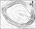
Ground plan of the Erdenburg.

Entrance gate
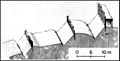
Cross section through the wall


Comments on the images
- In the photo (top right), a shallow ditch runs from the front left to the center of the picture, and to the left, a little higher up, another. Three concentric trenches can be identified that surround an oval about 230 m × 165 m in size.
- To the west was the entrance gate to the castle (see the ground plan drawing of the Erdenburg on the left edge of the picture). In the northeast the ramparts are not closed, the reason for this is unknown. The marking on the right on the floor plan indicates the location of the display board that can be seen in the two photos.
- The trenches were about two meters deep and the walls were reinforced with wood. The inner wall was probably built in box construction and consisted of rectangular wooden plots (see drawing of the entrance gate ), which were filled with earth (see drawing, cross section through the wall) - ( Murus Gallicus ).
See also
Individual evidence
- ↑ R. v. Uslar : Bergische Ringwwall in: Rheinisch-Bergischer Calendar 1963, p. 137 ff.
- ↑ a b c Erdenburg - examined in the laboratory, scientists discovered: Older than 2000 years , in: Rheinisch-Bergischer Calendar, 1970, p. 170
- ↑ The Erdenburg near Bensberg - first excavation of the Schutzstaffel between archeology and National Socialism, p. 127 accessed on July 29, 2015
Web links
- The Erdenburg near Bensberg - first excavation of the Schutzstaffel between archeology and National Socialism, accessed on March 29, 2015
Coordinates: 50 ° 58 ′ 14.1 ″ N , 7 ° 10 ′ 26.6 ″ E

Castles and ruins: Burg Bensberg | Großbernsau Castle | Moth Kippekausen | House Nesselrath | House Vorst
Castle stables and ramparts: House Bechhausen | Motte Beienburg | Castle mountains | Ringwall Castle Ring | Eifgenburg | Wall system Alte Burg Erberich | Ringwall installation Erdenburg | Wallburg Hohkeppel | Ringwall Lüderich | Wallburg Overath | Motte Saaler Mühle | Motte Wiebershausen / Niederscherf | Wallburg Ziegwebersberg | Moth Zoppesmur
Castles and mansions: Bensberg Castle | Dombach Manor | Eicherhof Palace | Eulenbroich Castle | House Haniel | Maltese Commandery | Lerbach Castle | Steinbreche House | Strauweiler Castle | House Venauen | Zweiffel Castle