
Ringwall castle ring
| Ringwall castle ring | ||
|---|---|---|
 Northeastern rampart 2017 |
||
| Creation time : | probably 10th to 11th century | |
| Castle type : | Niederungsburg | |
| Conservation status: | Burgstall, remains of a wall | |
| Place: | Kürten | |
| Geographical location | 51 ° 3 '38.8 " N , 7 ° 17' 52.7" E | |
|
||

The ring wall Burgring is a disused ring wall system north of the Sürth building on Landstrasse 286 from Kürten to Wipperfürth in North Rhine-Westphalia .
description
The road to Siefen and Burgheim runs west of the ring wall . To the north it is bounded by the floodplain of the small brook Sürth , which flows into the Kürtener Sülz after a short stretch . The nature reserve Sürthtal (Kürten) connects to the northeast . The castle complex, which was largely destroyed, originally had a size of 140 X 80 m. Part of the wall in the forest to the northeast has been preserved (see photo). In the meadow area adjoining to the south-west, the wall has been leveled so that today you can only see a terrace. At the time when arable farming was still practiced here, medieval shards of vessels have been found, the exact time of which is not known. It is believed that the ring castle from the 10/11. Century.
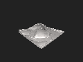
3D terrain model of the ramparts
See also
Individual evidence
- ^ A b Walter Janssen and Klaus Grewe : Prehistoric and early historical fortifications in the Rheinisch-Bergischer Kreis , in Rheinisch-Bergischer Calendar 1974, p. 117 f.
literature
- R. v. Uslar : A directory of the Bergischen ring walls, in: Romerike Berge, magazine for home care in the Bergisches Land , 2nd year 1951, Westdeutscher Verlag , Cologne and Opladen, p. 149 f.
- R. v. Uslar: Bergische Ringwwall, in: Rheinisch-Bergischer Calendar 1963, p. 137 ff.
Web links
- Archive of the Bergisches Geschichtsverein Rhein-Berg, Who should pay for monument protection? accessed on April 13, 2017
- Leitbild Kürten 2020, Cultural and Historical Evidence in the Municipality of Kürten, No. 131, accessed on April 13, 2017

Castles and ruins: Burg Bensberg | Großbernsau Castle | Moth Kippekausen | House Nesselrath | House Vorst
Castle stables and ramparts: House Bechhausen | Motte Beienburg | Castle mountains | Ringwall Castle Ring | Eifgenburg | Wall system Alte Burg Erberich | Ringwall installation Erdenburg | Wallburg Hohkeppel | Ringwall Lüderich | Wallburg Overath | Motte Saaler Mühle | Motte Wiebershausen / Niederscherf | Wallburg Ziegwebersberg | Moth Zoppesmur
Castles and mansions: Bensberg Castle | Dombach Manor | Eicherhof Palace | Eulenbroich Castle | House Haniel | Maltese Commandery | Lerbach Castle | Steinbreche House | Strauweiler Castle | House Venauen | Zweiffel Castle