El Fuerte
| El Fuerte | ||
|---|---|---|
|
Coordinates: 26 ° 25 ′ N , 108 ° 37 ′ W El Fuerte on the map of Sinaloa
|
||
| Basic data | ||
| Country | Mexico | |
| State | Sinaloa | |
| Municipio | El Fuerte | |
| Residents | 12,566 (2010) | |
| City insignia | ||
| Detailed data | ||
| surface | 4.02 km 2 | |
| Population density | 3,126 inhabitants / km 2 | |
| height | 85 m | |
| prefix | (+52) 698 | |
| Website | ||
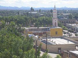
| El Fuerte - town view | ||
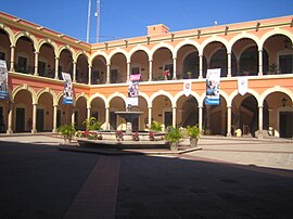
| El Fuerte - Town Hall (Palacio Municipal) | ||
El Fuerte is a former capital of the Mexican state Sinaloa and neighboring areas with about 13,500 inhabitants. Since 2009 the historic center of the small town has been recognized as Pueblo Mágico .
Location and climate
The place El Fuerte is located on the Río Fuerte in the western foothills of the Sierra Madre Occidental at a height of only about 85 m . The closest major city is the coastal town of Los Mochis , about 85 km (driving distance) to the southwest ; the provincial capital Culiacan is about 288 km to the southeast. The climate is temperate to warm; Rain (approx. 580 mm / year) falls almost exclusively in the summer half-year.
- CHEPE
The only large, surviving railway line for passenger traffic in Mexico, called CHEPE (Ferrocarril Chihuahua al Pacífico) , runs through the city . The railway line that runs through the Copper Gorge connects Los Mochis with Chihuahua , the capital of the state of the same name and one of the most important centers in northern Mexico. Many tourists choose El Fuerte as the boarding station for the CHEPE, as the city has more to offer during the day than Los Mochis. In addition, El Fuerte is climatically better and the railway line between Los Mochis and El Fuerte is more or less unspectacular.
Population development
| year | 2000 | 2010 |
| Residents | 10,728 | 12,566 |
The vast majority of the population is of Indian descent - mostly Yaquis and Mayos ; Mestizos are also numerous . Most of the time, however, Spanish is spoken .
economy
The cultivation of maize and beans etc. on the banks of the river formed the self-sufficiency- based livelihood of the population for centuries . In addition, the gold and silver mining in the nearby mountains contributed to the gradual growth of the place.
history
The place was founded in 1563 by the Spaniard Francisco de Ibarra ; In 1610 a fort was built, from which the name El Fuerte results . In 1824 the city briefly became the capital of Sonora and Sinaloa , Mexican states that at that time still extended as far as Arizona . At that time, the city, whose center still has colonial features, was considered the gateway to the USA .
Attractions
- The Templo del Sagrado Corazón de Jesús is dedicated to the Sacred Heart of Jesus . Already in the 16th century there was a church made of adobe bricks (adobes) , but from 1760 it was replaced by today's stone structure. The upper floors of the bell tower (campanario) were not built until the end of the 19th century.
- The town hall (Palacio Municipal) with its arcaded two-storey inner courtyard with a central fountain basin was built around 1900.
Web links
- El Fuerte - Photos + Info (inafed, Spanish)


