
Erbil (governorate)
| Arbīl / أربيل Hewlêr / هەولێر
Erbil |
|
|---|---|
  |
|
| Basic data | |
| Country | Iraq |
| Capital | Erbil |
| surface | 14,872.7 km² |
| Residents | 2,113,391 (2017) |
| density | 142 inhabitants per km² |
| ISO 3166-2 | IQ-AR |
| Website | hawler.gov.krd/en/ (English) |
| politics | |
| governor | Nawzad Hadi Mawlood |
 |
|
Coordinates: 36 ° 0 ′ N , 44 ° 0 ′ E

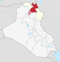
The Erbil Governorate ( Arabic أربيل, DMG Arbīl , Kurdish هەولێر Hewlêr ) is located in northeast Iraq and belongs to the Kurdistan Autonomous Region . The Erbil governorate has an area of 14,872.68 km² and is enclosed between Turkey , Iran and the Iraqi governorates of Ninawa , Kirkuk , as-Sulaimaniyya , Dahuk and Salah ad-Din . The governorate is subordinate to the government of the autonomous region.
In 2017 the population of the governorate was 2,113,391.
Districts
The governorate consists of the districts:
- Erbil
- Choman
- Koya
- Machmur / Mexmur ( controversial )
- Mergasor
- Shaqlawa
- Soran
On October 15, 2005, 99.36% of 830,570 voters voted for the new constitution.
Web links
Individual evidence
al-Anbar |
Babil |
Baghdad |
Basra |
Dahuk |
Dhi Qar |
Diyala |
Erbil |
Halabja |
Chervil |
Kirkuk |
Maisan |
al-Muthanna |
an-Najaf |
Ninawa |
al-Qadisiyya |
Salah ad-Din |
as-Sulaimaniyya |
Wasit
Autonomous Region: Kurdistan Autonomous Region