Ernst-Ludwig-Platz (Mainz)
The Ernst-Ludwig-Platz is a polygonal space in the old town of Mainz . It is located within the so-called Schlossviertel .
history
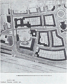
The palace square, previously Place de la Liberté , was made available to the troops of the German Confederation as a parade ground from 1816 . It served as a military complex of barracks, facilities and facilities with connections to the grounds of the garden field for training federal soldiers. The construction of the palace barracks, also known as the war hospital barracks, marked the beginning of the development of the Mainz Palace Square , for the infantry body regiment "Grand Duchess" (3rd Grand Ducal Hessian) No. 117 from 1840. After the abandonment of the military use of the area around the Electoral palace by the genius management of fortress Mainzthe site from 1899 was a competition as a new city center, between the old town and in the context of Neustadt on planning what a looping einbezog this defensible barracks building 1,903th Ernst-Ludwig-Strasse and Diether-von-Isenburg-Strasse were rebuilt, on which court and prison buildings as well as administration buildings such as the Grand Ducal Hessian wine-growing domain were built from 1902 ; which are significant for the history of the city of Mainz and the history of urban construction around 1900.
Since 1899 the square has been known as "Ernst-Ludwig-Platz", named after Grand Duke Ernst Ludwig of Hesse and the Rhine . In autumn 2009, the Mainz-Altstadt local council called for the square (together with the adjacent Deutschhausplatz , which was actually renamed) to be named “Platz der Mainzer Republik”. From Ernst-Ludwig-Platz past the Mainz district court to the Christ Church there is also Ernst-Ludwig-Straße, the renaming of which is not under discussion. In honor of the late former Federal Chancellor Helmut Kohl , part of the original Ernst-Ludwig-Platz was renamed “Helmut-Kohl-Platz” on April 3, 2018.
layout
The former electoral palace, together with the Deutschhaus (former grand ducal palace), armory , sauté dance , judicial buildings and St. Peter's Church, dominates the building structure of the Mainz government and palace district. The Deutschhausplatz, Ernst-Ludwig-Platz and Schlossplatz form the core of the public open space in the government district of the state capital. However, the spaces are not separated from each other by space-creating measures. Only a replica of the Dativius-Victor arch separates Ernst-Ludwig-Platz from Schlossplatz, which is now used as a car park.
The anniversary fountain, which was created for the controversially discussed 2000th anniversary of the city's founding in 1962, presents itself as an artistic contribution in public space . In keeping with the zeitgeist, concrete was used for the friezes and no high-quality materials, so the fountain is in poor condition today and does not do justice to the importance of the government district for the city. He stands on the green meadow of the square at the level of St. Peter's Church. Towards the courthouse, the square is delimited by roses in raised beds, which are also made of concrete. It is located in a monument zone in the old town , even if there is no building that really characterizes the square.
Surrounding streets
A total of three streets surround Ernst-Ludwig-Platz : to the north, the square is delimited from the Rhine by the Schlossgymnasium or the Electoral Palace and Peter-Altmeier-Allee. The Große Bleiche runs along the south-east side . The Kaiser-Friedrich-Strasse with the adjoining House of Representatives and the Ministry of Environment, Forestry and Consumer Protection runs along the south-west side of the site, while the judicial district, the north-west side forms. The Ernst-Ludwig-Straße leads to the law courts along the middle of the square.
Design concepts
As part of an urban planning competition , the individual squares within the district are to be assigned attributes according to their unique selling points and identities, such as: B. Deutschhausplatz “Representation”, Ernst-Ludwig-Platz “Recreation” and Schlossplatz “Representation with quality of stay”.
The favorable location of the urban open space bordering the Rhine landscape is to be used more effectively in the future in order to link the castle district more effectively with the banks of the Rhine. The recreational and recreational functions of the square are to be strengthened and major events ( Rhineland-Palatinate Open Air , church days, public viewing, etc.), as well as permanent installations (ice rink), are only allowed to a limited extent. The city planning office does not want a multi-purpose, “hard” event space at Ernst-Ludwig-Platz.
Individual evidence
- ↑ " The guide de la ville de Mayence contenant la denomination de ses six sections, rues, maisons et de leurs numéros, ainsi que des habitans avec leurs qualités, états, professions ou métiers." Pfeiffer, Mainz to IX [= 1800]
- ^ Alfred Börckel: Mainz as a fortress and garrison from Roman times to the present . Verlag von J. Diemer, Mainz 1913, p. 180 .
- ↑ Winfried Bliss: The fortress plans of the Prussian War Ministry : an inventory. Volume 1. therein: Site plan of the harbor front and of the construction site of the bomb-proof war hospital ; colored hand drawing 1: 880 from 1841, 81 × 64 cm, E70366
- ↑ sensor-magazin.de
- ↑ Mainz gets "Helmut-Kohl-Platz"
- ^ Forum Government Quarter - Mainz (PDF; 9.1 MB)
Coordinates: 50 ° 0 ′ 17 ″ N , 8 ° 16 ′ 12 ″ E


