
FFH area NSG Hechtmoor
|
FFH area NSG Hechtmoor
|
||
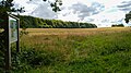
.jpg) Degenerate raised bog in the Hechtmoor FFH area |
||
| location | Schleswig-Holstein , Germany | |
| surface | 34 ha | |
| Identifier | 1323-301 | |
| WDPA ID | 555517802 | |
| Natura 2000 ID | DE1323301 | |
| FFH area | 34 ha | |
| Geographical location | 54 ° 40 ' N , 9 ° 36' E | |
|
||
| Sea level | from 36 m to 38 m | |
| Setup date | January 2010 | |
| administration | Ministry for the Environment, Agriculture and Rural Areas of the State of Schleswig-Holstein | |
| Legal basis | Section 32 Paragraphs 2 to 4 BNatSchG in conjunction with Section 23 LNatSchG | |

The FFH area NSG Hechtmoor is a NATURA 2000 protected area in Schleswig-Holstein in the Schleswig Flensburg district in the municipality of Satrup (Mittelangeln) . The FFH area is located in the fishing natural area , which, according to the landscape profile of the Federal Agency for Nature Conservation, is one of the "landscapes of minor importance". The FFH area has an area of 34 ha. The largest extent is in a west-east direction and is 1 km. The inner area of the area consists of bog areas of various types, the edge of quarry forest. The FFH area is bounded in the east by the Mühlenstrom flowing water . The rest of the edge is bounded by a ditch that absorbs the excess surface water and feeds it into the mill stream. This flows further north into the Bondenau . Most of the year the southern and western rifts are dry. He is no longer cared for there either.
A nature trail leads through the central axis of the area. On the north-west edge there is a parking lot with a notice board of the visitor information system (BIS) of the state of Schleswig-Holstein, which provides information about the nature reserve and the NATURA 2000 reserve. The same can be found at the other end of the hiking trail on the south-eastern edge and at the second southern access (hiking trail to Osterbunsbüll). However, there are no parking spaces at either entrance. You can use the parking lot of the FFH area Rehbergholz and Schwennholz on the L22 Esmarksüderfeld, 250 m away . Unfortunately, the steel folding boxes for the BIS leaflets are often empty. The leaflets can be downloaded from the Internet as PDF files, see web links.
FFH area history and nature conservation area
The NATURA 2000 standard data sheet for this FFH area was created in November 1999 by the State Office for Agriculture, Environment and Rural Areas (LLUR) of the State of Schleswig-Holstein, proposed in August 2000 as an area of Community importance (GGB), in December 2004 confirmed by the EU as GGB and designated nationally as a special conservation area (BEG) in January 2010 according to § 32 paragraph 2 to 4 BNatSchG in conjunction with § 23 LNatSchG. The Hechtmoor was declared a nature reserve in 1941 and is the largest still largely preserved high moor in fishing. The geobotany working group in Schleswig-Holstein and Hamburg eV was commissioned by the LLUR to look after the area.
The area contains legally protected biotopes such as B. several water-filled former peat cuttings. The largest in the southeast of the area is now with the uncharacteristic fens crab claw overgrown, see picture gallery. In the immediate vicinity is the FFH area Rehbergholz and Schwennholz with the largest contiguous beech forest in fishing on the southeast edge.
FFH conservation object
According to the standard data sheet from May 2019, the following FFH habitat types and species with the corresponding assessments of the conservation status of the environmental authority of the European Union have been reported (common abbreviation (BfN)):
Habitat types according to Annex I of the EU Directive: (* = priority habitat type ) The area details in the standard data sheet correspond to those in the 1st follow-up mapping from 2010.
- 3150 Natural and near-natural nutrient-rich still waters with pondweed frog-bite societies (overall rating C)
- 3160 Dystrophic still waters (overall rating C)
- 6430 Moist tall herbaceous vegetation (overall assessment C)
- 7120 Renatured degraded raised bogs (overall assessment B)
- 7140 transitional and vibrating lawn bogs (overall assessment B)
- 7150 peat bog ditches with rush communities (overall rating B)
- 91D0 * Bog forests (overall assessment C)
Species according to Annex II of Directive 92/43 / EEC:
- 1042 Greater moss damsel (overall assessment B)
FFH conservation objectives
Of the FFH conservation objects, the following have been declared as conservation objectives of community interest :
- 7120 Renatured degraded raised bogs
- 7140 Transitional and swinging lawn bogs
- 7150 Peat swamp with rush communities
- 1042 Great Moss Maiden
The declared aim is to restore the raised bog with the corresponding fauna and flora.
FFH analysis and assessment
The chapter Analysis and Assessment deals with the possibilities for the maintenance and development of the conservation objectives in the FFH area Hechtmoor, see management plan.
FFH catalog of measures
In the management plan, the catalog of measures is the most important instrument for the maintenance and development of the FFH conservation objectives. For the FFH area NSG Hechtmoor, the measures are also described in an action map for a better overview. For the further development of the bog complex, keeping the bog areas free of woody plants, preventing the inflow of nutrient-rich drainage water from the surrounding intensively agricultural areas and preventing the drainage of nutrient-free rainwater from the bog are the targeted measures. The crab claws, which are actually at home in phosphate-rich lakes, have settled in the water-filled peat cutters. It displaces the flora typical of oligotrophic bog lakes and, according to the area manager, threatens the habitat of four very rare species of tumbler beetle that need open water there. With the help of a raft, the number of crab claws is regularly contained. These measures are associated with high costs. The ownership structure of the FFH area with over 30 parcel owners makes it difficult to coordinate development measures that go beyond the prohibition of deterioration.
FFH success control and monitoring of the measures
Monitoring takes place in Schleswig-Holstein every 6 years. As of July 24, 2020, the last monitoring was carried out on November 30, 2011 and documented in a text and map material from the commissioned company.
Picture gallery

Information board at the parking lot Moorweg and west entrance to the Hechtmoor

Redder at the east entrance to Hechtmoor
South entrance to the Hechtmoor with information board
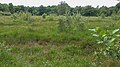
Degenerate raised bog in the pike bog
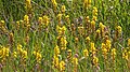
Bog lily in the pike bog
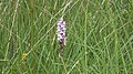
Spotted orchid in the pike bog

Bell heather in the pike bog
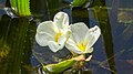
Flowers of the crab claw in the pike bog
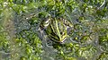
Pond frog in the small biotope in the pike bog
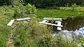
Raft of the area supervisor to contain the crayfish claw in the wet biotope in the pike bog
.jpg)
.jpg)
.jpg)
.jpg)
.jpg)
.jpg)
.jpg)
.jpg)
.jpg)
.jpg)
Web links
- Reading instructions for standard data sheets for areas according to the Habitats Directive (92/43 / EEC) and the Birds Directive (2009/147 / EC) in accordance with the Commission's implementing decision on the data sheet for the transmission of information on Natura 2000 areas (2011 / 484 / EU) (PDF; 588 KB) In .: Schleswig-Holstein state portal . Ministry of Energy Transition, Agriculture, Environment and Rural Areas of the State of Schleswig-Holstein, accessed on July 23, 2020
- The habitat types and species (protected objects) of the Habitats and Birds Protection Directive , Federal Agency for Nature Conservation, October 24, 2019
- Leaflet 5906 Hechtmoor (PDF) State Office for Nature and the Environment of Schleswig-Holstein, November 2005, accessed on July 24, 2020
- Leaflet 5939 Hechtmoor (PDF) State Office for Nature and the Environment of Schleswig-Holstein, September 2019, accessed on July 24, 2020
- List of FFH areas in Schleswig-Holstein
- Website of the area manager AG-Geobotanik , accessed on August 29, 2020
Individual evidence
- ↑ Landscape profile 70001 fishing swans and Danish welfare. Federal Agency for Nature Conservation, March 1, 2012, accessed on July 9, 2020 .
- ↑ Natural assessment of the landscapes in Germany. (PDF; 1.51 MB) Federal Agency for Nature Conservation, November 2011, accessed on July 9, 2020 .
- ↑ Management plan FFH DE - 1323-301 "NSG Hechtmoor". (PDF; 828 KB) Appendix 1: Overview map. In: Schleswig-Holstein state portal. Ministry for Energy Transition, Agriculture, Environment and Rural Areas of the State of Schleswig-Holstein, October 2014, accessed on July 23, 2020 .
- ↑ Management plan FFH DE - 1323-301 "NSG Hechtmoor". (PDF; 828 KB) Appendix 1: Overview map aerial photo. In: Schleswig-Holstein state portal. Ministry for Energy Transition, Agriculture, Environment and Rural Areas of the State of Schleswig-Holstein, October 2014, accessed on July 23, 2020 .
- ↑ STANDARD DATA SHEET for special protection areas (SPA). proposed areas of Community importance (vGGB), areas of Community importance (GGB) and special conservation areas (BEG). (PDF; 62 KB) EN1323301 Official Journal of the European Union EN L 198/41. In: Schleswig-Holstein state portal. Ministry for Energy Transition, Agriculture, Environment and Rural Areas of the State of Schleswig-Holstein, May 2019, accessed on July 23, 2020 .
- ↑ Ordinance on the Hechtmoor nature reserve in the Dammholm district, Schleswig district. (PDF; 822 KB) In: Schleswig-Holstein state portal. Landesregíerung Schleswig-Holstein, September 2, 1941, accessed on July 22, 2020 .
- ^ Andrea Kühl: Care of protected areas in Schleswig-Holstein according to § 20 LNatSchG. (PDF) Ser. No. 1.6.2 NSG Hechtmoor. In: Schleswig-Holstein state portal. State Office for Agriculture, Environment and Rural Areas of the State of Schleswig-Holstein (LLUR), December 2019, p. 3 , accessed on July 28, 2020 .
- ↑ Biotope no .: 325386056 423 Water-filled peat cut in the pike bog. In: Biotope mapping Schleswig-Holstein. Ministry for Energy Transition, Agriculture, Environment, Nature and Digitization of the State of Schleswig-Holstein, September 13, 2018, accessed on July 24, 2020 (after opening the window, click on the biotope mapping field).
- ↑ List of habitat types occurring in Germany in the Habitats Directive. (PDF) Federal Agency for Nature Conservation, May 13, 2013, pp. 1–4 , accessed on July 23, 2020 .
- ↑ List of the species occurring in Germany in Annexes II, IV, V of the Habitats Directive (92/43 / EEC) **. (PDF) Federal Agency for Nature Conservation, May 12, 2016, pp. 1–8 , accessed on July 23, 2020 .
- ↑ STANDARD DATA SHEET for special protection areas (SPA). proposed areas of Community importance (vGGB), areas of Community importance (GGB) and special conservation areas (BEG). (PDF; 62 KB) 3.1. Habitat types occurring in the area and their assessment of the area. In: Schleswig-Holstein state portal. Ministry for Energy Transition, Agriculture, Environment and Rural Areas of the State of Schleswig-Holstein, May 2019, p. 3 , accessed on July 23, 2020 .
- ↑ a b Follow-up mapping / monitoring of habitat types in FFH areas and coherence areas in Schleswig-Holstein 2007-2012 Article on the Hechtmoor FFH area (1323-301). (PDF; 77 KB) Table 2: Comparison of the habitat types mapped in 2010 with the information in the standard data sheet (MLUR 2006) and the results of the initial mapping (Triops 2004). Planning office Mordhorst-Bretschneider GmbH, February 10, 2012, p. 18 , accessed on July 23, 2020 .
- ↑ Assessment schemes for assessing the degree of conservation of species and habitat types as the basis for nationwide FFH monitoring Part II: Habitat types according to Annex I of the Habitats Directive (with the exception of marine and coastal habitats). (PDF) 3150 Natural and near-natural nutrient-rich still waters with pondweed or frog-bite communities. Federal Agency for Nature Conservation, October 2017, p. 35 , accessed on July 23, 2020 .
- ↑ Assessment schemes for assessing the degree of conservation of species and habitat types as a basis for nationwide FFH monitoring Part II: Habitat types according to Annex I of the Habitats Directive (with the exception of marine and coastal habitats) Status: October 2017. (PDF) Federal Agency for Nature Conservation, October 2017, p. 38 , accessed on July 23, 2020 .
- ↑ Assessment schemes for assessing the degree of conservation of species and habitat types as the basis for nationwide FFH monitoring, Part II: Habitat types according to Annex I of the Habitats Directive (with the exception of marine and coastal habitats) Status: October 2017. (PDF) 6430 Moist tall herbaceous meadows. Federal Agency for Nature Conservation, October 2017, p. 112 , accessed on July 23, 2020 .
- ↑ a b Evaluation schemes for evaluating the degree of conservation of species and habitat types as the basis for nationwide FFH monitoring Part II: Habitat types according to Annex I of the Habitats Directive (with the exception of marine and coastal habitats). (PDF) 7120 Renatured degraded raised bogs. Federal Agency for Nature Conservation, October 2017, p. 129 , accessed on July 23, 2020 .
- ↑ a b Evaluation schemes for evaluating the degree of conservation of species and habitat types as the basis for nationwide FFH monitoring Part II: Habitat types according to Annex I of the Habitats Directive (with the exception of marine and coastal habitats). (PDF) 7140 transitional and vibrating lawn bogs. Federal Agency for Nature Conservation, October 2017, p. 132 , accessed on July 23, 2020 .
- ↑ a b Evaluation schemes for evaluating the degree of conservation of species and habitat types as the basis for nationwide FFH monitoring Part II: Habitat types according to Annex I of the Habitats Directive (with the exception of marine and coastal habitats). (PDF) Federal Agency for Nature Conservation, October 2017, p. 136 , accessed on July 23, 2020 .
- ↑ Assessment schemes for assessing the degree of conservation of species and habitat types as the basis for nationwide FFH monitoring Part II: Habitat types according to Annex I of the Habitats Directive (with the exception of marine and coastal habitats). 91D0 * swamp forests. Federal Agency for Nature Conservation, October 2017, p. 215 , accessed on July 23, 2020 .
- ↑ STANDARD DATA SHEET for special protection areas (SPA). proposed areas of Community importance (vGGB), areas of Community importance (GGB) and special conservation areas (BEG). (PDF; 62 KB) 3.2. Species according to Article 4 of Directive 2009/147 / EC and Annex II of Directive 92/43 / EEC and assessment of the area in this regard. In: DE1323301 Official Journal of the European Union DE L 198/41. Ministry for Energy Transition, Agriculture, Environment and Rural Areas of the State of Schleswig-Holstein, May 2019, p. 4 , accessed on July 23, 2020 .
- ↑ a b Evaluation schemes for the evaluation of the degree of conservation of species and habitat types as the basis for nationwide FFH monitoring Part I: Species according to Annex II and IV of the FFH Directive (with the exception of marine mammals). (PDF) Great Moss Maiden - Leucorrhinia pectoralis. Federal Agency for Nature Conservation, October 2017, p. 106 , accessed on July 23, 2020 .
- ↑ Management plan for the fauna-flora-habitat area DE-1323-301 "NSG Hechtmoor". (PDF; 752 KB) 4.1. Conservation and restoration goals. In: Schleswig-Holstein state portal. Ministry for Energy Transition, Agriculture, Environment and Rural Areas of the State of Schleswig-Holstein, December 2014, p. 14 , accessed on July 23, 2020 .
- ↑ Conservation objectives for the area DE-1323-301 "NSG Hechtmoor", designated as a site of Community importance. (PDF; 48 KB) In: Schleswig-Holstein state portal. Ministry of Energy Transition, Agriculture, Environment and Rural Areas of the State of Schleswig-Holstein, accessed on July 24, 2020 .
- ↑ Management plan for the fauna-flora-habitat area DE-1323-301 "NSG Hechtmoor". (PDF; 752 KB) 5. Analysis and evaluation. In: Schleswig-Holstein state portal. Ministry for Energy Transition, Agriculture, Environment and Rural Areas of the State of Schleswig-Holstein, December 2014, pp. 14-16 , accessed on July 23, 2020 .
- ↑ Management plan for the fauna-flora-habitat area DE-1323-301 "NSG Hechtmoor". (PDF; 752 KB) 6. Catalog of measures. In: Schleswig-Holstein state portal. Ministry for the Energy Transition, Agriculture, Environment and Rural Areas of the State of Schleswig-Holstein, December 2014, pp. 16-19 , accessed on July 24, 2020 .
- ↑ Management plan H DE - 1323-301 "NSG Hechtmoor". (PDF; 233 KB) Annex 6: Map of measures. In: Schleswig-Holstein state portal. Ministry for Energy Transition, Agriculture, Environment and Rural Areas of the State of Schleswig-Holstein, December 2014, accessed on July 24, 2020 .
- ↑ New version 2002 of the regional plan for the planning area V Landesteil Schleswig (Schleswig-Holstein North) of the state Schleswig-Holstein - district-free city of Flensburg, districts of North Friesland and Schleswig-Flensburg. 5.3 Areas of particular importance for nature and the landscape and priority areas for nature conservation, item (7), paragraph 4. In: State regulations and state legislation. State government of Schleswig-Holstein, accessed on June 30, 2020 : “The NATURA 2000 areas are not subject to deterioration. It means that existing uses and activities can be continued in the future. The same applies to projects and plans that do not conflict with the conservation goals for a single area. Before the approval or implementation of new projects and measures, however, the compatibility with the conservation objectives of a corresponding area must be checked. "
- ↑ Management plan for the fauna-flora-habitat area DE-1323-301 "NSG Hechtmoor". (PDF; 752 KB) 7. Success control and monitoring of the measures. In: Schleswig-Holstein state portal. Ministry for Energy Transition, Agriculture, Environment and Rural Areas of the State of Schleswig-Holstein, December 2014, p. 19 , accessed on July 22, 2020 .
- ↑ Habitats Directive (92/43 / EEC) Annex I. (PDF) Article 11. In: Internet portal of the European Union. Council of the European Union, May 21, 1992, p. 10 , accessed on April 4, 2020 : "The Member States monitor the conservation status of the species and habitats referred to in Article 2"
- ↑ FFH follow-up monitoring NSG Hechtmoor. (PDF; 4675 KB) In: Schleswig-Holstein state portal . Ministry for Energy Transition, Agriculture, Environment and Rural Areas of the State of Schleswig-Holstein, July 7, 2011, accessed on July 24, 2020 (overview biotope type and LRT map).