
Farrenberg
| Farrenberg | ||
|---|---|---|
 Aerial view |
||
| height | 820.8 m above sea level NHN | |
| location | Baden-Wuerttemberg , Germany | |
| Mountains | Swabian Alb | |
| Coordinates | 48 ° 23 '21 " N , 9 ° 4' 15" E | |
|
||
| Type | Zeugenberg | |
| rock | White Jura | |

The Farrenberg ( 820.8 m above sea level ) is the local mountain of Mössingen or the Mössingen district of Talheim in Baden-Württemberg . From there a narrow road leads to the plateau.
The Farrenberg glider airfield is located on the Farrenberg .
geography
The Farrenberg can also be reached on hiking trails that start from the Mössinger Olgahöhe (see below) or from Talheim. From Ziegler's slide there is a view of the Albtrauf and part of the Tübingen district . Another view emerges from the Bismarckskapf in the northwest corner of the Farrenberg plateau.
In inversion weather conditions in the cold season, the Farrenberg often juts out over the Steinlachtal valley , which lies in the fog .
At 780 m above sea level NHN high mountain spur in the east are the ruins of Andeck Castle . Every year on Whit Monday the Andeckfest of the Talheim local group of the Swabian Alb Association takes place there.
prehistory
Bronze Age finds on the Farrenberg indicate a hilltop settlement from the Urnfield Age (10th / 9th century BC), which was very likely inhabited until the Hallstatt period (8th – 5th century BC).
geology
The mountain plateau is due to the stratified surface formed by the banked limestone of the White Jura beta. The Farrenberg was separated from the plateau of the Swabian Alb in the south by retrograde erosion from Buchbach and Holderbach . He is therefore considered a mountain of witnesses .
use
The pasture of the Mössinger breeding bulls (Farren) used to be on the Farrenberg. Hence the name of the mountain comes. The plateau is now grazed with sheep and is thus kept open for flight operations.
The 602.4 m above sea level is located at the western foot of the Farrenberg . NHN high Olgahöhe, a recreational area of the city of Mössingen. The Olgahöhe is equipped with a forest playground and a parking lot for hikers. It is the starting point for ascents of the Farrenberg. On the Saturday after the summer solstice, the Swabian Alb Association lights a Midsummer bonfire there every year . On the plateau of the Farrenberg, floor ore was also collected earlier , which formed there as the weathering residue of the Malm limestone.
The Farrenberg is located in the 2,646 hectare Albrand landscape protection area , which was designated by ordinance of the Tübingen District Office of August 8, 1969. It is also part of the 3,568 hectare FFH area Albtrauf between Mössingen and Gönningen .
Picture gallery

The Farrenberg seen from Talheim (June 2010)

The Farrenberg as seen from Belsen . In the center of the picture is the Olgahöhe

The Farrenberg as seen from Kornbühl near Salmendingen on the Alb plateau (February 2007)

On the Farrenberg plateau
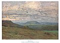
Painting by Karl Schickhardt , early 20th century.


Others
The Farrenberg repeatedly served as a motif for the Mössingen painter and wood cutter Andreas Felger .