
Firnhaberauheide
|
"Firnhaberauheide" nature reserve
|
||
 Meager meadow with meadow sage in the southern part of the Firnhaberauheide |
||
| location | Augsburg , Swabia , Bavaria , Germany | |
| surface | 14.64 ha | |
| Identifier | NSG-00470.01 | |
| WDPA ID | 163103 | |
| Natura 2000 ID | DE-7431-301 | |
| Geographical location | 48 ° 25 ' N , 10 ° 54' E | |
|
||
| Sea level | from 462 m to 465 m | |
| Setup date | April 19, 1994 | |
| Framework plan | Land use plan with integrated landscape planning (2013) | |
| administration |
Government of Swabia, Subject 51 - Nature Conservation ; Maintenance by the Landschaftspflegeverband Stadt Augsburg eV |
|
| particularities | The only known occurrence of the red-bodied grasshopper in the entire Lech Valley | |


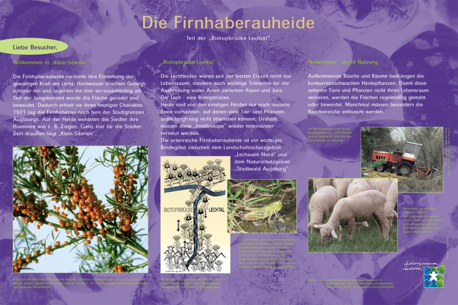
The Firnhaberauheide is a nature reserve in the north of Augsburg, east of the Lech, and mainly comprises open grassland with hedge fringes and individual tree islands. It is registered under the identifier NSG-00470.01, covers an area of 15 ha and is divided into a southern and a slightly smaller northern part by the Stuttgart – Munich motorway . The Firnhaberauheide is an important stepping stone in the Lechtal biotope network.
location
The Firnhaberauheide lies on the Lechhausen district of the city of Augsburg. The southern part is bounded in the south by the Firnhaberau district , in the west by the Lech and in the north by the A 8. The northern part connects to the motorway in the south and ends in the west on a path along the river towards the Europaweiher of the city of Gersthofen . In the north the biotope reaches up to the Augsburg garbage dump . The entire area is closed off in the east by the "Oberen Auweg", which leads from the residential buildings in the south via the A 8 to the closed area of the garbage mountain.
history
The Firnhaberauheide was once located off the Augsburg city limits in a riparian forest east of the Lech. It served the Kommerzienrat Friedrich August Firnhaber (1823–1887) as a hunting ground. Settlers called the area "Little Siberia" and let their animals graze on the barren grasslands, especially sheep and goats. From 1921 the heather area was continuously reduced in order to gain building land for residential houses. Only a small remainder of the Lechheide remained as a buffer strip . In the years 1976 to 1979 the heath was to be converted into a public green area as part of the redesign of the Lechufer green areas. For this purpose it was planned to cover the gravel soil with humus and to sow park lawns. Thanks to the commitment of Augsburg conservationists, however, this could be prevented. In 1991 the fertile topsoil was removed in the southern part of a section of the motorway in order to create a raw soil location . Finally, the entire area was placed under nature protection in 1994. Since 2001, a traveling shepherd has been bringing sheep and goats into the area for a few days three times a year to graze the growth and to counteract wood succession . Previously, the grass areas were mowed once a year.
Heathland
Floods of the Lech washed rock gravel down the river and deposited it in terraces. Since the last ice age, the heather has been an important stepping stone for the spread of species between the Alps and the Jura . Today there are only relics left of the heathen, on which many species cannot permanently survive. Therefore, these "biotope islands" should be connected to each other again. The Firnhaberauheide acts as a link between the Lechauen Nord nature reserve and the Augsburg municipal forest nature reserve .
literature
- Information board "Firnhaberauheide". In: Landschaftspflegeverband Stadt Augsburg . Retrieved January 14, 2014 (JPEG graphic; 416 KB).
- Nicolas Liebig: Heath, heavy current and autobahn . Biodiversity (Series 3). In: Augsburger Allgemeine . June 7, 2010 ( article online ).
- Kurt R. Schmidt: Landschaftspflegeverband Augsburg: tasks, organization, work results . In: Stadt + Grün . tape 7 , 2002, p. 15-24 .