Fischbach (Ammersee)
| Fischbach | ||
|
Fischbach in the Herrschinger Moos |
||
| Data | ||
| Water code | DE : 164318 | |
| location | Starnberg District , Upper Bavaria , Bavaria , Germany | |
| River system | Danube | |
| Drain over | Ammersee → Amper → Isar → Danube → Black Sea | |
| origin |
Pilsensee 48 ° 0 ′ 54 ″ N , 11 ° 10 ′ 56 ″ E |
|
| Source height | 534.4 m above sea level NN | |
| muzzle | in the Ammersee coordinates: 48 ° 0 ′ 8 ″ N , 11 ° 10 ′ 0 ″ E 48 ° 0 ′ 8 ″ N , 11 ° 10 ′ 0 ″ E |
|
| Mouth height | 533 m above sea level NN | |
| Height difference | 1.4 m | |
| Bottom slope | 0.67 ‰ | |
| length | 2.1 km | |
| Communities | Herrsching am Ammersee | |
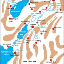
The Fischbach is the approximately 2.1 kilometers long outflow of the Pilsensee and one of the tributaries of the Ammersee in Upper Bavaria .
course
The Fischbach begins at the southern end of the Pilsensee and flows through the extensive reeds of the Herrschinger Moos nature reserve , where it is widened in sections like a lake. It crosses under the Munich – Herrsching S-Bahn line and State Road 2067 and ends in Herrsching in the Herrsching Bay of Ammersee.


